Fayl:Map of Russian districts, 2010-01-19.svg

Size of this PNG preview of this SVG file: 800 × 462 piksel. Boshqa oʻlchamlari: 320 × 185 piksel | 640 × 369 piksel | 1 024 × 591 piksel | 1 280 × 738 piksel | 2 560 × 1 477 piksel | 1 092 × 630 piksel.
Asl fayl (SVG fayl, asl oʻlchamlari 1 092 × 630 piksel, fayl hajmi: 196 KB)
| Taʼrif |
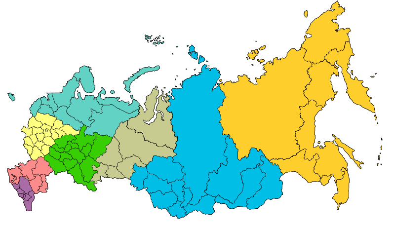
Map of the Federal districts of Russia with merged subjects (01.03.2008, last merger Chita Oblast+Agin-Buryat Autonomous Okrug to form Zabaykalsky Krai.) Central Federal District Southern Federal District Northwestern Federal District Far Eastern Federal District Siberian Federal District Urals Federal District Volga Federal District
North Caucasian Federal District |
| Sanasi | (UTC) |
| Manba | |
| Muallif |
|
| This is a retouched picture, which means that it has been digitally altered from its original version. The original can be viewed here: Map of Russian districts, 2008-03-01.svg:
|
I, the copyright holder of this work, hereby publish it under the following license:
This file is licensed under the Creative Commons Attribution-Share Alike 2.5 Generic license.
- Siz erkinsiz:
- ulashishga – ishlanmani nusxalash, tarqatish va uzatish
- remiks qilishga – ishni moslashtirishga
- Quyidagi shartlar asosida:
- atribut – Siz tegishli litsenziyaga havolani taqdim etishingiz va oʻzgartirishlar kiritilganligini koʻrsatishingiz kerak. Siz buni har qanday oqilona yoʻl bilan qilishingiz mumkin, lekin litsenziar Sizni yoki Sizning foydalanishingizni ma'qullashini taklif qiladigan tarzda emas.
- bir xil ulashish – Agar Siz materialni remiks qilsangiz, oʻzgartirsangiz yoki unga asoslansangiz, oʻz hissalaringizni asl nusxadagi kabi bir xil yoki mos litsenziya ostida tarqatishingiz kerak.
Original upload log
This image is a derivative work of the following images:
- File:Map_of_Russian_districts,_2008-03-01.svg licensed with Cc-by-sa-2.5
- 2008-03-03T23:20:48Z Lokal Profil 1092x630 (260469 Bytes) Removed surrounding countries
- 2008-03-03T23:15:39Z Lokal Profil 1092x630 (296735 Bytes) {{Information |Description=Map of the [[:en:Federal districts of Russia|Federal districts of Russia]] with merged subjects (01.03.2008, last merger [[w:en:Chita Oblast|Chita Oblast]]+[[w:en:Agin-Buryat Autonomous Okrug|Agin-B
Uploaded with derivativeFX
Fayl tarixi
Faylning biror paytdagi holatini koʻrish uchun tegishli sana/vaqtga bosingiz.
| Sana/Vaqt | Miniatura | Oʻlchamlari | Foydalanuvchi | Izoh | |
|---|---|---|---|---|---|
| joriy | 14:44, 23-Mart 2014 | | 1 092 × 630 (196 KB) | Denniss | Reverted to version as of 23:59, 22 March 2014 |
| 13:29, 23-Mart 2014 |  | 1 092 × 630 (220 KB) | Preguntador | Reverted to version as of 11:28, 22 March 2014 | |
| 23:59, 22-Mart 2014 |  | 1 092 × 630 (196 KB) | Tibet2014 | The file is named 2010-01-19, please upload new version as new file | |
| 11:28, 22-Mart 2014 |  | 1 092 × 630 (220 KB) | Anton-rigin | Reverted to version as of 22:00, 21 March 2014/We can dispute about legality of referendum, but Russian federal districts are Russian domestic policy. | |
| 01:59, 22-Mart 2014 |  | 1 092 × 630 (196 KB) | Bobek | Reverted to version as of 16:25, 19 January 2010 | |
| 22:00, 21-Mart 2014 |  | 1 092 × 630 (220 KB) | Knyaz-1988 | New version | |
| 16:25, 19-Yanvar 2010 |  | 1 092 × 630 (196 KB) | SeNeKa~commonswiki | {{Information |Description=Map of the Federal districts of Russia with merged subjects (01.03.2008, last merger Chita Oblast+Agin-Buryat Autonomous Okrug to fo |
Fayllarga ishoratlar
Bu faylga quyidagi sahifa bogʻlangan:
Faylning global foydalanilishi
Ushbu fayl quyidagi vikilarda ishlatilyapti:
- av.wikipedia.org loyihasida foydalanilishi
- bg.wikipedia.org loyihasida foydalanilishi
- bxr.wikipedia.org loyihasida foydalanilishi
- cy.wikipedia.org loyihasida foydalanilishi
- de.wikipedia.org loyihasida foydalanilishi
- de.wikivoyage.org loyihasida foydalanilishi
- en.wikipedia.org loyihasida foydalanilishi
- eo.wikipedia.org loyihasida foydalanilishi
- fa.wikipedia.org loyihasida foydalanilishi
- fi.wikipedia.org loyihasida foydalanilishi
- fr.wikipedia.org loyihasida foydalanilishi
- hr.wikipedia.org loyihasida foydalanilishi
- hu.wikipedia.org loyihasida foydalanilishi
- id.wikipedia.org loyihasida foydalanilishi
- koi.wikipedia.org loyihasida foydalanilishi
- Шаблон:Федерал кытшшез Рочмуын
- Волгадор федерал кытш
- Категория:Ойвыв-Рытвыв федерал кытш
- Категория:Сибир федерал кытш
- Категория:Волгадор федерал кытш
- Категория:Урал федерал кытш
- Категория:Лунвыв федерал кытш
- Категория:Медшӧр федерал кытш
- Ылісь Асыввыв федерал кытш
- Категория:Ылісь Асыввыв федерал кытш
- Категория:Федерал кытшшез Рочмуын
- Категория:Ылiсь Асыввыв федерал кытш
- Категория:Медшöр федерал кытш
- mk.wikipedia.org loyihasida foydalanilishi
Ushbu faylni koʻproq global foydalanishdan koʻring.