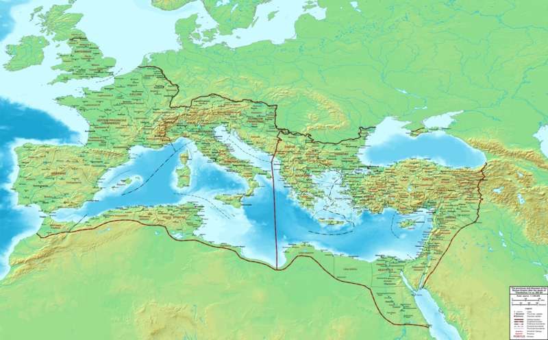
Fayl:The Roman Empire ca 400 AD.png

Bu prevyuning hajmi: 800 × 496 piksel. Boshqa oʻlchamlari: 320 × 198 piksel | 640 × 397 piksel | 1 024 × 635 piksel | 1 280 × 793 piksel | 2 560 × 1 587 piksel | 4 339 × 2 689 piksel.
Asl fayl (4 339 × 2 689 piksel, fayl hajmi: 12,8 MB, MIME tipi: image/png)
Fayl tarixi
Faylning biror paytdagi holatini koʻrish uchun tegishli sana/vaqtga bosingiz.
| Sana/Vaqt | Miniatura | Oʻlchamlari | Foydalanuvchi | Izoh | |
|---|---|---|---|---|---|
| joriy | 22:27, 19-Fevral 2015 |  | 4 339 × 2 689 (12,8 MB) | Cplakidas | added potential location of Valentia beyond Hadrian's Wall, removed provincial boundaries in Britannia as too tentative |
| 13:03, 21-Iyul 2011 |  | 4 339 × 2 689 (10,9 MB) | Cplakidas | fixed Persian border, differentiated between Eastern and Western empire, different borders for praet. prefectures | |
| 02:37, 21-Mart 2009 |  | 4 475 × 2 600 (9,99 MB) | Cplakidas | minor corrections | |
| 12:30, 29-May 2008 |  | 3 800 × 2 370 (8,1 MB) | Cplakidas | ||
| 12:17, 29-May 2008 |  | 4 560 × 2 850 (11,22 MB) | Cplakidas | clearer version & addition of the Armenian satrapies | |
| 02:02, 30-Dekabr 2007 |  | 3 380 × 2 120 (5,96 MB) | Cplakidas | added names of dioceses, legend box, various minor adjustments | |
| 14:27, 13-Dekabr 2007 |  | 3 550 × 2 200 (6,65 MB) | Cplakidas | new improved version made with Inkscape, slight corrections in borders, added several cities in Africa & Spain | |
| 19:27, 12-Noyabr 2007 |  | 3 550 × 2 200 (4,75 MB) | Cplakidas | minor corrections in southern Gaul | |
| 12:58, 5-Noyabr 2007 |  | 3 550 × 2 200 (4,75 MB) | Cplakidas | New version, with some corrections & additions | |
| 16:55, 31-Oktyabr 2007 |  | 3 436 × 2 142 (4,5 MB) | Cplakidas | {{Information |Description=Map of the Roman Empire ca. 400 AD, showing the administrative division into dioceses and provinces, as well as the major cities. The demarcation between Eastern and Western Empires is noted in red. |Source=Base map found at |
Fayllarga ishoratlar
Bu faylga quyidagi sahifa bogʻlangan:
Faylning global foydalanilishi
Ushbu fayl quyidagi vikilarda ishlatilyapti:
- af.wikipedia.org loyihasida foydalanilishi
- ar.wikipedia.org loyihasida foydalanilishi
- ary.wikipedia.org loyihasida foydalanilishi
- ast.wikipedia.org loyihasida foydalanilishi
- bg.wikipedia.org loyihasida foydalanilishi
- bn.wikipedia.org loyihasida foydalanilishi
- ca.wikipedia.org loyihasida foydalanilishi
- ceb.wikipedia.org loyihasida foydalanilishi
- cs.wikipedia.org loyihasida foydalanilishi
- de.wikipedia.org loyihasida foydalanilishi
- el.wikipedia.org loyihasida foydalanilishi
- en.wikipedia.org loyihasida foydalanilishi
- eo.wikipedia.org loyihasida foydalanilishi
- es.wikipedia.org loyihasida foydalanilishi
- et.wikipedia.org loyihasida foydalanilishi
- fr.wikipedia.org loyihasida foydalanilishi
- he.wikipedia.org loyihasida foydalanilishi
- hi.wikipedia.org loyihasida foydalanilishi
- hr.wikipedia.org loyihasida foydalanilishi
- hu.wikipedia.org loyihasida foydalanilishi
- id.wikipedia.org loyihasida foydalanilishi
- it.wikipedia.org loyihasida foydalanilishi
- ko.wikipedia.org loyihasida foydalanilishi
- la.wikipedia.org loyihasida foydalanilishi
- lt.wikipedia.org loyihasida foydalanilishi
- nl.wikipedia.org loyihasida foydalanilishi
Ushbu faylni koʻproq global foydalanishdan koʻring.


