Fayl:WaroftheAustrianSuccession.png

Bu prevyuning hajmi: 800 × 370 piksel. Boshqa oʻlchamlari: 320 × 148 piksel | 640 × 296 piksel | 1 357 × 628 piksel.
Asl fayl (1 357 × 628 piksel, fayl hajmi: 27 KB, MIME tipi: image/png)
Qisqa izoh
| Taʼrif |
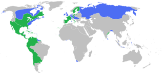
English: Locator map of the competing sides of the War of the Austrian Succession before outset of the war (1740).
|
| Sanasi | |
| Manba | Oʻzimning ishim |
| Muallif | Gabagool |
Litsenziyalash
I, the copyright holder of this work, hereby publish it under the following license:
This file is licensed under the Creative Commons Attribution 3.0 Unported license.
- Siz erkinsiz:
- ulashishga – ishlanmani nusxalash, tarqatish va uzatish
- remiks qilishga – ishni moslashtirishga
- Quyidagi shartlar asosida:
- atribut – Siz tegishli litsenziyaga havolani taqdim etishingiz va oʻzgartirishlar kiritilganligini koʻrsatishingiz kerak. Siz buni har qanday oqilona yoʻl bilan qilishingiz mumkin, lekin litsenziar Sizni yoki Sizning foydalanishingizni ma'qullashini taklif qiladigan tarzda emas.
Fayl tarixi
Faylning biror paytdagi holatini koʻrish uchun tegishli sana/vaqtga bosingiz.
| Sana/Vaqt | Miniatura | Oʻlchamlari | Foydalanuvchi | Izoh | |
|---|---|---|---|---|---|
| joriy | 01:57, 7-Avgust 2017 | | 1 357 × 628 (27 KB) | Carpolomew | Fixed a lot of problems, at least in Europe - Piedmont is now blue, Corsica is now green, and Austrian possessions which were shown as neutral (Lombardy, Netherlands) are now blue. |
| 14:25, 11-May 2010 |  | 1 357 × 628 (48 KB) | Kieran4 | Added Dutch Empire. | |
| 14:24, 11-May 2010 |  | 1 357 × 628 (48 KB) | Kieran4 | Added the Dutch Empire. | |
| 01:35, 26-Mart 2010 |  | 1 357 × 628 (48 KB) | Gabagool | some further adjustments | |
| 04:28, 20-Mart 2010 |  | 1 357 × 628 (48 KB) | Gabagool | some corrections (NA) after notice and help by User:Magicpiano | |
| 20:05, 25-Iyun 2009 |  | 1 357 × 628 (41 KB) | Gabagool | correction | |
| 19:38, 25-Iyun 2009 |  | 1 357 × 628 (41 KB) | Gabagool | {{Information |Description={{en|1=Locator map of the competing sides of the War of the Austrian Succession before outset of the war (1740). <br> Blue: Great Britain, Holy Roman Empire with more. Green: France, Prussia, Spain with more. <br> (Partially bas |
Fayllarga ishoratlar
Bu faylga quyidagi sahifa bogʻlangan:
Faylning global foydalanilishi
Ushbu fayl quyidagi vikilarda ishlatilyapti:
- ast.wikipedia.org loyihasida foydalanilishi
- ca.wikipedia.org loyihasida foydalanilishi
- de.wikipedia.org loyihasida foydalanilishi
- en.wikipedia.org loyihasida foydalanilishi
- es.wikipedia.org loyihasida foydalanilishi
- et.wikipedia.org loyihasida foydalanilishi
- fa.wikipedia.org loyihasida foydalanilishi
- fr.wikipedia.org loyihasida foydalanilishi
- fr.wikiversity.org loyihasida foydalanilishi
- it.wikipedia.org loyihasida foydalanilishi
- ko.wikipedia.org loyihasida foydalanilishi
- nl.wikipedia.org loyihasida foydalanilishi
- pl.wikipedia.org loyihasida foydalanilishi
- ro.wikipedia.org loyihasida foydalanilishi
- ru.wikipedia.org loyihasida foydalanilishi
- sh.wikipedia.org loyihasida foydalanilishi
- sr.wikipedia.org loyihasida foydalanilishi
- th.wikipedia.org loyihasida foydalanilishi
- vi.wikipedia.org loyihasida foydalanilishi
- www.wikidata.org loyihasida foydalanilishi