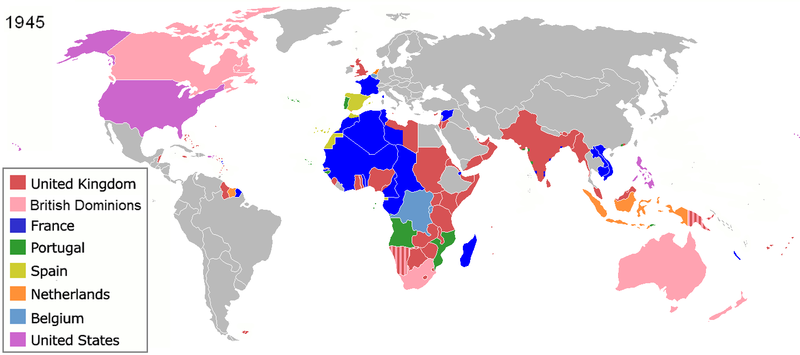
Fayl:Colonization 1945.png

Bu prevyuning hajmi: 800 × 355 piksel. Boshqa oʻlchamlari: 320 × 142 piksel | 640 × 284 piksel | 1 438 × 638 piksel.
Asl fayl (1 438 × 638 piksel, fayl hajmi: 85 KB, MIME tipi: image/png)
Fayl tarixi
Faylning biror paytdagi holatini koʻrish uchun tegishli sana/vaqtga bosingiz.
| Sana/Vaqt | Miniatura | Oʻlchamlari | Foydalanuvchi | Izoh | |
|---|---|---|---|---|---|
| joriy | 17:20, 28-Iyun 2019 |  | 1 438 × 638 (85 KB) | Andres.tv | Recovering the large size of the image and improving the color for France. |
| 22:08, 20-Iyul 2018 |  | 800 × 355 (1,09 MB) | SuperSucker | UK | |
| 07:42, 10-Avgust 2016 |  | 1 438 × 638 (92 KB) | Sebastiano Mugnaio | Reverted to version as of 14:08, 26 August 2012 (UTC) - sorry, meant this one... | |
| 07:41, 10-Avgust 2016 |  | 1 438 × 638 (92 KB) | Sebastiano Mugnaio | Reverted to version as of 14:08, 26 August 2012 (UTC) - Japan and Germany as colonies is rather awkward. | |
| 10:58, 14-Avgust 2015 |  | 1 438 × 638 (89 KB) | Palaeozoic99 | Fixed Newfoundland; it was a British Dominion from 1907-1949. | |
| 18:56, 11-Avgust 2015 |  | 1 438 × 638 (103 KB) | Alghenius | Corrected | |
| 14:08, 26-Avgust 2012 |  | 1 438 × 638 (92 KB) | Hamodi1234 | Fixed Brazil | |
| 14:05, 26-Avgust 2012 |  | 1 438 × 638 (92 KB) | Hamodi1234 | Fixed Brazil and Syria | |
| 14:04, 24-Iyul 2012 |  | 1 438 × 638 (81 KB) | Soerfm | Legend | |
| 09:14, 9-Iyun 2012 |  | 1 425 × 625 (46 KB) | Ozzorro~commonswiki | Repositioned image and fixed colours to match other maps in the 'Colonisation' series (1492, 1550, 1660, 1754, 1800, 1822, 1885, 1914, 1938, 1959, 1974, 2007) - also corrected island positions. Suggestion: The 'British Dominions' classification exist... |
Fayllarga ishoratlar
Bu faylga bogʻlangan sahifalar yoʻq.
Faylning global foydalanilishi
Ushbu fayl quyidagi vikilarda ishlatilyapti:
- af.wikipedia.org loyihasida foydalanilishi
- am.wikipedia.org loyihasida foydalanilishi
- ar.wikipedia.org loyihasida foydalanilishi
- ast.wikipedia.org loyihasida foydalanilishi
- azb.wikipedia.org loyihasida foydalanilishi
- az.wikipedia.org loyihasida foydalanilishi
- be.wikipedia.org loyihasida foydalanilishi
- bg.wikipedia.org loyihasida foydalanilishi
- ca.wikipedia.org loyihasida foydalanilishi
- cs.wikipedia.org loyihasida foydalanilishi
- cy.wikipedia.org loyihasida foydalanilishi
- da.wikipedia.org loyihasida foydalanilishi
- de.wikipedia.org loyihasida foydalanilishi
- Zweiter Weltkrieg
- Kolonialmacht
- Dekolonisation
- Benutzer:HerbertErwin/Portal:Gesellschaftskritik/Dekolonisation
- Benutzer:HerbertErwin/Portal:Gesellschaftskritik/Unterseite 7
- Benutzer:Ulflulfl/Karten
- Travaux et mémoires de l’Institut d’ethnologie
- Benutzer:Casadopovo/EURAFRICA
- Mémoires de l’Institut d’ethnologie
- en.wikipedia.org loyihasida foydalanilishi
- Self-determination
- Free trade
- Atlantic Charter
- Decolonization
- Cold War
- User:Aris Katsaris
- History of Western civilization
- Aftermath of World War II
- History of colonialism
- Talk:World War II/Infobox/Archive 5
- Nazi propaganda and the United Kingdom
- User:Rlandale
- Western influence on Africa
- Wikipedia:Graphics Lab/Map workshop/Archive/Dec 2015
- Theories of imperialism
- User:Falcaorib
- en.wikibooks.org loyihasida foydalanilishi
- eo.wikipedia.org loyihasida foydalanilishi
Ushbu faylni koʻproq global foydalanishdan koʻring.


