Fayl:Gorno badakhshan map.png

Bu prevyuning hajmi: 800 × 598 piksel. Boshqa oʻlchamlari: 320 × 239 piksel | 640 × 479 piksel | 948 × 709 piksel.
Asl fayl (948 × 709 piksel, fayl hajmi: 20 KB, MIME tipi: image/png)
Qisqa izoh
| Taʼrif |
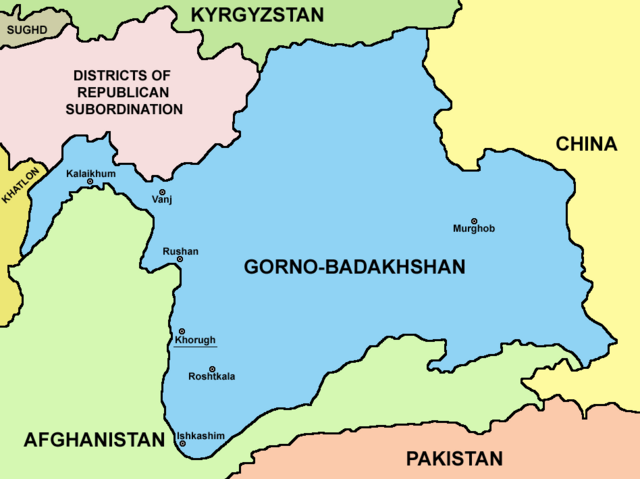
English: Map of Gorno-Badakhshan. |
| Sanasi | |
| Manba | Oʻzimning ishim |
| Muallif | PANONIAN |
Litsenziyalash
I, the copyright holder of this work, hereby publish it under the following license:
| This file is made available under the Creative Commons CC0 1.0 Universal Public Domain Dedication. | |
| The person who associated a work with this deed has dedicated the work to the public domain by waiving all of their rights to the work worldwide under copyright law, including all related and neighboring rights, to the extent allowed by law. You can copy, modify, distribute and perform the work, even for commercial purposes, all without asking permission.
|
Fayl tarixi
Faylning biror paytdagi holatini koʻrish uchun tegishli sana/vaqtga bosingiz.
| Sana/Vaqt | Miniatura | Oʻlchamlari | Foydalanuvchi | Izoh | |
|---|---|---|---|---|---|
| joriy | 21:15, 9-Avgust 2023 | | 948 × 709 (20 KB) | Lojwe | Cropped 2 % horizontally, 5 % vertically using CropTool with precise mode. |
| 04:08, 27-Sentyabr 2021 |  | 970 × 749 (57 KB) | GPinkerton | Reverted to version as of 09:58, 14 May 2013 (UTC) COM:CROP | |
| 17:25, 4-Aprel 2021 |  | 970 × 749 (47 KB) | Claude Zygiel | Differenciate international boundaries (black) from administrative of Tadjikistan (grey) | |
| 09:58, 14-May 2013 |  | 970 × 749 (57 KB) | PANONIAN | {{Information |Description ={{en|1=Map of Gorno-Badakhshan.}} |Source ={{own}} |Author =PANONIAN |Date =2013 |Permission = |other_versions = }} |
Fayllarga ishoratlar
Bu faylga quyidagi sahifa bogʻlangan:
Faylning global foydalanilishi
Ushbu fayl quyidagi vikilarda ishlatilyapti:
- be.wikipedia.org loyihasida foydalanilishi
- bg.wikipedia.org loyihasida foydalanilishi
- cs.wikipedia.org loyihasida foydalanilishi
- el.wikipedia.org loyihasida foydalanilishi
- en.wikipedia.org loyihasida foydalanilishi
- eo.wikipedia.org loyihasida foydalanilishi
- es.wikipedia.org loyihasida foydalanilishi
- et.wikipedia.org loyihasida foydalanilishi
- fa.wikipedia.org loyihasida foydalanilishi
- fi.wikipedia.org loyihasida foydalanilishi
- fr.wikipedia.org loyihasida foydalanilishi
- gl.wikipedia.org loyihasida foydalanilishi
- hi.wikipedia.org loyihasida foydalanilishi
- id.wikipedia.org loyihasida foydalanilishi
- incubator.wikimedia.org loyihasida foydalanilishi
- it.wikipedia.org loyihasida foydalanilishi
- kaa.wikipedia.org loyihasida foydalanilishi
- ko.wikipedia.org loyihasida foydalanilishi
- lt.wikipedia.org loyihasida foydalanilishi
- pl.wikipedia.org loyihasida foydalanilishi
- pnb.wikipedia.org loyihasida foydalanilishi
- ps.wikipedia.org loyihasida foydalanilishi
- pt.wikipedia.org loyihasida foydalanilishi
- sr.wikipedia.org loyihasida foydalanilishi
- sv.wikipedia.org loyihasida foydalanilishi
- ta.wikipedia.org loyihasida foydalanilishi
- tg.wikipedia.org loyihasida foydalanilishi
- tr.wikipedia.org loyihasida foydalanilishi
- ur.wikipedia.org loyihasida foydalanilishi
- vi.wikipedia.org loyihasida foydalanilishi
- xmf.wikipedia.org loyihasida foydalanilishi
- zh.wikipedia.org loyihasida foydalanilishi