Fayl:Lower Egypt-en.png

Bu prevyuning hajmi: 600 × 600 piksel. Boshqa oʻlchamlari: 240 × 240 piksel | 480 × 480 piksel | 994 × 994 piksel.
Asl fayl (994 × 994 piksel, fayl hajmi: 188 KB, MIME tipi: image/png)
Qisqa izoh
| Taʼrif |
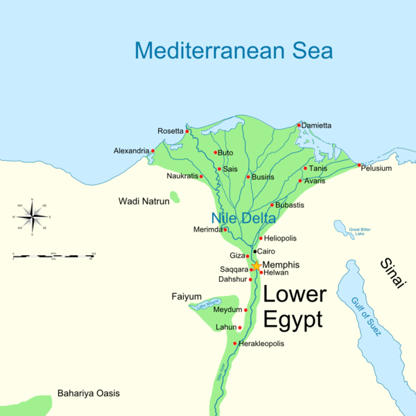
English: Map of Lower Ancient Egypt, showing the Nile and major cities and sites of the Dynastic period (c. 3150 BC to 30 BC). |
| Sanasi | (UTC) |
| Manba | |
| Muallif |
|
| Other versions |
Derivative works of this file: |

|
This historical map image could be re-created using vector graphics as an SVG file. This has several advantages; see Commons:Media for cleanup for more information. If an SVG form of this image is available, please upload it and afterwards replace this template with
{{vector version available|new image name}}.
It is recommended to name the SVG file “Lower Egypt-en.svg”—then the template Vector version available (or Vva) does not need the new image name parameter. |
| This is a retouched picture, which means that it has been digitally altered from its original version. Modifications: Cropped image to use as base map. The original can be viewed here: Ancient Egypt map-en.svg:
|
Litsenziyalash
I, the copyright holder of this work, hereby publish it under the following licenses:
This file is licensed under the Creative Commons Attribution-Share Alike 3.0 Unported, 2.5 Generic, 2.0 Generic and 1.0 Generic license.
- Siz erkinsiz:
- ulashishga – ishlanmani nusxalash, tarqatish va uzatish
- remiks qilishga – ishni moslashtirishga
- Quyidagi shartlar asosida:
- atribut – Siz tegishli litsenziyaga havolani taqdim etishingiz va oʻzgartirishlar kiritilganligini koʻrsatishingiz kerak. Siz buni har qanday oqilona yoʻl bilan qilishingiz mumkin, lekin litsenziar Sizni yoki Sizning foydalanishingizni ma'qullashini taklif qiladigan tarzda emas.
- bir xil ulashish – Agar Siz materialni remiks qilsangiz, oʻzgartirsangiz yoki unga asoslansangiz, oʻz hissalaringizni asl nusxadagi kabi bir xil yoki mos litsenziya ostida tarqatishingiz kerak.

|
Ushbu hujjatdan nusxa ko‘chirish, tarqatish va/yoki o‘zgartirish uchun GNU Erkin guvohnoma litsenziyasi (GNU Free Documentation License), 1.2 va har qanday keyingi versiyalar shartlariga muvofiq ruxsat berilgan yoki Ochiq kodli dasturlar jamiyati (Free Software Foundation) tomonidan chop etilgan; oʻzgarmas boʻlimlarsiz, oldingi muqova matnlari va orqa muqova matnlarisiz. Litsenziya nusxasi GNU Erkin guvohnoma litsenziyasi (GNU Free Documentation License) boʻlimiga kiritilgan. |
Siz oʻzingiz xohlagan litsenziyani tanlashingiz mumkin.
Original upload log
This image is a derivative work of the following images:
- File:Ancient_Egypt_map-en.svg licensed with Cc-by-sa-3.0,2.5,2.0,1.0, GFDL
- 2009-02-20T11:28:29Z Bibi Saint-Pol 1577x3219 (422457 Bytes) fix translation mistake on the windrose
- 2009-01-30T12:13:53Z Bibi Saint-Pol 1577x3219 (422444 Bytes) fix position of Nile Delta
- 2009-01-29T12:21:11Z Bibi Saint-Pol 1577x3219 (422383 Bytes) remove wrong text, adjust frame
- 2009-01-29T12:05:11Z Bibi Saint-Pol 1577x3219 (422757 Bytes) {{Assessments|1=Ancient Egypt map.svg|enwiki=1}} __NOTOC__ == {{int:filedesc}} == {{inkscape}} {{Information |Description= {{en|Map of Ancient Egypt, showing the Nile up to the fifth cataract, and major cities and sites of th
Uploaded with derivativeFX
Fayl tarixi
Faylning biror paytdagi holatini koʻrish uchun tegishli sana/vaqtga bosingiz.
| Sana/Vaqt | Miniatura | Oʻlchamlari | Foydalanuvchi | Izoh | |
|---|---|---|---|---|---|
| joriy | 16:30, 14-Fevral 2014 | | 994 × 994 (188 KB) | Andy king50 | -border |
| 18:00, 29-Iyun 2009 |  | 1 000 × 1 000 (193 KB) | MinisterForBadTimes | Hopefully fixed border this time | |
| 17:59, 29-Iyun 2009 |  | 1 000 × 1 000 (193 KB) | MinisterForBadTimes | Moved border | |
| 17:57, 29-Iyun 2009 |  | 1 000 × 1 000 (193 KB) | MinisterForBadTimes | Added border | |
| 17:49, 29-Iyun 2009 |  | 1 000 × 1 000 (190 KB) | MinisterForBadTimes | {{Information |Description={{en|Map of Lower Ancient Egypt, showing the Nile and major cities and sites of the Dynastic period (c. 3150 BC to 30 BC). |Source=*File:Ancient_Egypt_map-en.svg |Date=2009-06-29 18:49 (UTC) |Author=*[[:File:Ancient_Egypt_ |
Fayllarga ishoratlar
Bu faylga quyidagi sahifa bogʻlangan:
Faylning global foydalanilishi
Ushbu fayl quyidagi vikilarda ishlatilyapti:
- ar.wikipedia.org loyihasida foydalanilishi
- arz.wikipedia.org loyihasida foydalanilishi
- az.wikipedia.org loyihasida foydalanilishi
- bg.wikipedia.org loyihasida foydalanilishi
- br.wikipedia.org loyihasida foydalanilishi
- cs.wikipedia.org loyihasida foydalanilishi
- de.wikipedia.org loyihasida foydalanilishi
- de.wikivoyage.org loyihasida foydalanilishi
- el.wikipedia.org loyihasida foydalanilishi
- en.wikipedia.org loyihasida foydalanilishi
- es.wikipedia.org loyihasida foydalanilishi
- et.wikipedia.org loyihasida foydalanilishi
- eu.wikipedia.org loyihasida foydalanilishi
- fr.wikipedia.org loyihasida foydalanilishi
- he.wikipedia.org loyihasida foydalanilishi
- hu.wikipedia.org loyihasida foydalanilishi
- it.wikipedia.org loyihasida foydalanilishi
- ja.wikipedia.org loyihasida foydalanilishi
Ushbu faylni koʻproq global foydalanishdan koʻring.