Fayl:Map of Morris Co, Ks, USA.png

Bu prevyuning hajmi: 800 × 586 piksel. Boshqa oʻlchamlari: 320 × 235 piksel | 640 × 469 piksel | 1 004 × 736 piksel.
Asl fayl (1 004 × 736 piksel, fayl hajmi: 343 KB, MIME tipi: image/png)
Qisqa izoh
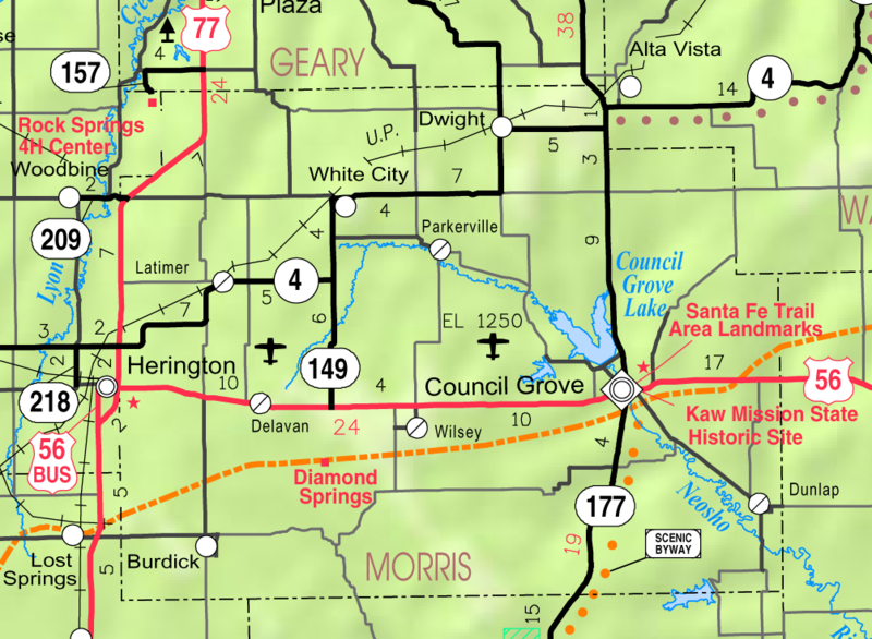
| Taʼrif | This map of Morris County, Kansas, USA, is copied at a resolution of 300 pixels/inch from the original PDF file. |
| Sanasi | |
| Manba | Kansas 2005–2006 Official Transportation Map [1] (map legend) |
| Muallif | Designed and published by the Kansas Department of Transportation. |
| Ruxsat (Bu faylning takror foydalanilishi) |
Litsenziyalash
| This work has been released into the public domain by its author, Kansas Department of Transportation. This applies worldwide. In some countries this may not be legally possible; if so: Kansas Department of Transportation grants anyone the right to use this work for any purpose, without any conditions, unless such conditions are required by law.
|
This map is published by the Kansas Department of Transportation and is distributed to the public free of charge. KDOT makes no warranties, guarantees, or representations for accuracy of this information and assumes no liability for errors or omissions. Maps produced using tax payer dollars are free for public use.
Fayl tarixi
Faylning biror paytdagi holatini koʻrish uchun tegishli sana/vaqtga bosingiz.
| Sana/Vaqt | Miniatura | Oʻlchamlari | Foydalanuvchi | Izoh | |
|---|---|---|---|---|---|
| joriy | 03:28, 3-Aprel 2006 | | 1 004 × 736 (343 KB) | Moverton | Source: Kansas 2005-2006 Official Transportation Map {{PD-US}} |
Fayllarga ishoratlar
Bu faylga quyidagi sahifa bogʻlangan:
Faylning global foydalanilishi
Ushbu fayl quyidagi vikilarda ishlatilyapti:
- ar.wikipedia.org loyihasida foydalanilishi
- arz.wikipedia.org loyihasida foydalanilishi
- azb.wikipedia.org loyihasida foydalanilishi
- ca.wikipedia.org loyihasida foydalanilishi
- ceb.wikipedia.org loyihasida foydalanilishi
- ce.wikipedia.org loyihasida foydalanilishi
- en.wikipedia.org loyihasida foydalanilishi
- es.wikipedia.org loyihasida foydalanilishi
- eu.wikipedia.org loyihasida foydalanilishi
- fa.wikipedia.org loyihasida foydalanilishi
- fr.wikipedia.org loyihasida foydalanilishi
- ht.wikipedia.org loyihasida foydalanilishi
- it.wikipedia.org loyihasida foydalanilishi
- lld.wikipedia.org loyihasida foydalanilishi
- nl.wikipedia.org loyihasida foydalanilishi
- pl.wikipedia.org loyihasida foydalanilishi
- pt.wikipedia.org loyihasida foydalanilishi
- sh.wikipedia.org loyihasida foydalanilishi
- simple.wikipedia.org loyihasida foydalanilishi
- sr.wikipedia.org loyihasida foydalanilishi
Ushbu faylni koʻproq global foydalanishdan koʻring.