Fayl:SevenYearsWar.png

Bu prevyuning hajmi: 800 × 370 piksel. Boshqa oʻlchamlari: 320 × 148 piksel | 640 × 296 piksel | 1 357 × 628 piksel.
Asl fayl (1 357 × 628 piksel, fayl hajmi: 41 KB, MIME tipi: image/png)

|
This military map image could be re-created using vector graphics as an SVG file. This has several advantages; see Commons:Media for cleanup for more information. If an SVG form of this image is available, please upload it and afterwards replace this template with
{{vector version available|new image name}}.
It is recommended to name the SVG file “SevenYearsWar.svg”—then the template Vector version available (or Vva) does not need the new image name parameter. |
Qisqa izoh
| Taʼrif |
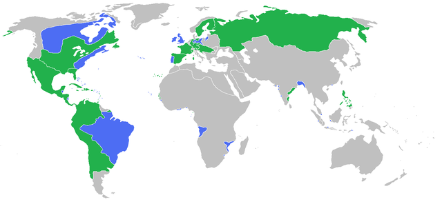
English: Locator map of the competing sides of the Seven Years War before outset of the war (mid-1750s). Blue: Great Britain, Portugal with more. Green: France, Spain with more. Great Britain, Prussia, Portugal, with allies
France, Spain, Austria, Russia, Sweden with allies Français : Carte montrant les forces en présence lors de la guerre de Sept Ans (milieu des années 1750).
Grande Bretagne, Prusse, Portugal, leurs alliés et dépendances
France, Espagne, Autriche, Russie, Suède, leurs alliés et dépendances (Partially based on Atlas of World History (2007) - There was also a treaty in 1783, Imperialism and Revolutions, map) |
| Sanasi | |
| Manba | Oʻzimning ishim |
| Muallif | Gabagool |
Litsenziyalash
I, the copyright holder of this work, hereby publish it under the following license:
This file is licensed under the Creative Commons Attribution 3.0 Unported license.
- Siz erkinsiz:
- ulashishga – ishlanmani nusxalash, tarqatish va uzatish
- remiks qilishga – ishni moslashtirishga
- Quyidagi shartlar asosida:
- atribut – Siz tegishli litsenziyaga havolani taqdim etishingiz va oʻzgartirishlar kiritilganligini koʻrsatishingiz kerak. Siz buni har qanday oqilona yoʻl bilan qilishingiz mumkin, lekin litsenziar Sizni yoki Sizning foydalanishingizni ma'qullashini taklif qiladigan tarzda emas.
Fayl tarixi
Faylning biror paytdagi holatini koʻrish uchun tegishli sana/vaqtga bosingiz.
| Sana/Vaqt | Miniatura | Oʻlchamlari | Foydalanuvchi | Izoh | |
|---|---|---|---|---|---|
| joriy | 15:54, 23-Iyun 2009 | | 1 357 × 628 (41 KB) | Gabagool | corrected India more appropriatly |
| 13:59, 11-Iyun 2009 |  | 1 357 × 628 (41 KB) | Gabagool | some fixes | |
| 11:16, 11-Iyun 2009 |  | 1 357 × 628 (41 KB) | Gabagool | more details in Germany | |
| 22:20, 6-Iyun 2009 |  | 1 357 × 628 (41 KB) | Gabagool | {{Information |Description={{en|1=Locator map of the competing sides of the Seven Years War before outset of the war (early 1750s).<br> Blue: Great Britain, Portugal with more. Green: France, Spain with more. Light green: French largest expansion in India |
Fayllarga ishoratlar
Bu faylga quyidagi 2 sahifalar bogʻlangan:
Faylning global foydalanilishi
Ushbu fayl quyidagi vikilarda ishlatilyapti:
- af.wikipedia.org loyihasida foydalanilishi
- als.wikipedia.org loyihasida foydalanilishi
- an.wikipedia.org loyihasida foydalanilishi
- ar.wikipedia.org loyihasida foydalanilishi
- arz.wikipedia.org loyihasida foydalanilishi
- ast.wikipedia.org loyihasida foydalanilishi
- az.wikipedia.org loyihasida foydalanilishi
- ba.wikipedia.org loyihasida foydalanilishi
- bg.wikipedia.org loyihasida foydalanilishi
- bn.wikipedia.org loyihasida foydalanilishi
- br.wikipedia.org loyihasida foydalanilishi
- bs.wikipedia.org loyihasida foydalanilishi
- ca.wikipedia.org loyihasida foydalanilishi
- cs.wikipedia.org loyihasida foydalanilishi
- da.wikipedia.org loyihasida foydalanilishi
- de.wikipedia.org loyihasida foydalanilishi
- dsb.wikipedia.org loyihasida foydalanilishi
- en.wikipedia.org loyihasida foydalanilishi
- eo.wikipedia.org loyihasida foydalanilishi
- es.wikipedia.org loyihasida foydalanilishi
- fa.wikipedia.org loyihasida foydalanilishi
- fi.wikipedia.org loyihasida foydalanilishi
- fr.wikipedia.org loyihasida foydalanilishi
- ga.wikipedia.org loyihasida foydalanilishi
- he.wikipedia.org loyihasida foydalanilishi
- hi.wikipedia.org loyihasida foydalanilishi
- hsb.wikipedia.org loyihasida foydalanilishi
- is.wikipedia.org loyihasida foydalanilishi
- it.wikipedia.org loyihasida foydalanilishi
- ja.wikipedia.org loyihasida foydalanilishi
- ko.wikipedia.org loyihasida foydalanilishi
- lt.wikipedia.org loyihasida foydalanilishi
Ushbu faylni koʻproq global foydalanishdan koʻring.