Fayl:Britain and Ireland satellite image bright.png

Bu prevyuning hajmi: 522 × 600 piksel. Boshqa oʻlchamlari: 209 × 240 piksel | 418 × 480 piksel | 668 × 768 piksel | 1 024 × 1 177 piksel.
Asl fayl (1 024 × 1 177 piksel, fayl hajmi: 2,21 MB, MIME tipi: image/png)
Qisqa izoh
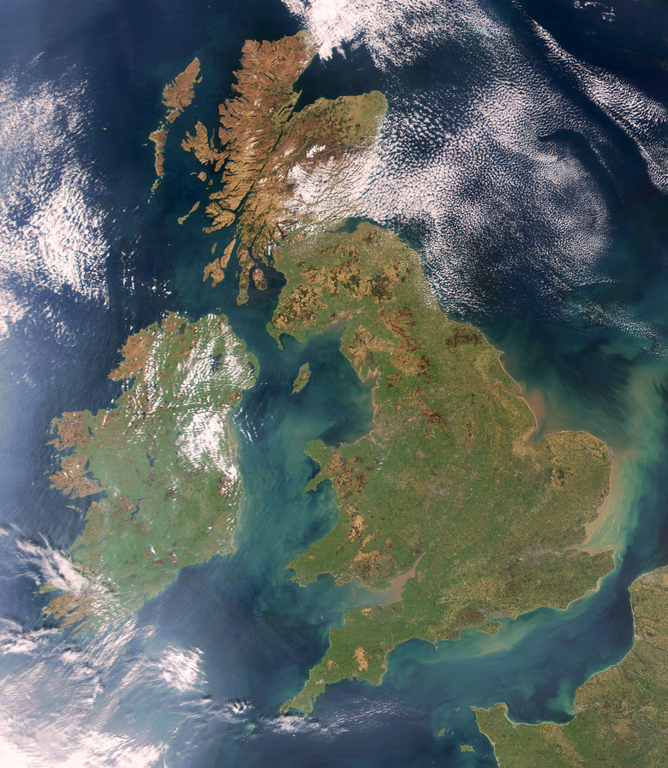
Brightened version of Image:United_Kingdom_satellite_image.png. Enhancement performed with w:en:the GIMP.
Litsenziyalash
| This file is in the public domain in the United States because it was solely created by NASA. NASA copyright policy states that "NASA material is not protected by copyright unless noted". (See Template:PD-USGov, NASA copyright policy page or JPL Image Use Policy.) | ||
 |
Warnings:
|
Fayl tarixi
Faylning biror paytdagi holatini koʻrish uchun tegishli sana/vaqtga bosingiz.
| Sana/Vaqt | Miniatura | Oʻlchamlari | Foydalanuvchi | Izoh | |
|---|---|---|---|---|---|
| joriy | 19:32, 7-Aprel 2009 | | 1 024 × 1 177 (2,21 MB) | HighKing | Used original NASA source instead of version that had political border drawn in |
| 18:24, 5-Aprel 2009 |  | 917 × 1 124 (1,15 MB) | HighKing | Cropped a little finer | |
| 18:06, 5-Aprel 2009 |  | 934 × 1 284 (1,87 MB) | HighKing | {{Information |Description={{en|1=Brightened and correctly renamed version of Image:United_Kingdom_satellite_image.png. Enhancement performed with w:en:the GIMP.}} |Source=NASA |Author=NASA |Date= |Permission= |other_versions= }} <!--{{ImageUplo |
Fayllarga ishoratlar
Bu faylga bogʻlangan sahifalar yoʻq.
Faylning global foydalanilishi
Ushbu fayl quyidagi vikilarda ishlatilyapti:
- en.wikipedia.org loyihasida foydalanilishi
- Wikipedia:Userboxes/Location/Europe
- Names of the British Isles
- User:CsikosLo
- User:MariAdkins
- User:Tk420
- British nationalism
- User talk:HighKing/BritishIsles
- Template:User British-Isles
- User:KingKarp
- User:Knox490
- User:Byzantium Purple
- Wikipedia:Userboxes/Life/Ancestry
- Wikipedia talk:Userboxes/Archive 13
- Template:User British Isles≠UK,GBorEngland
- User:Adam9007
- Wikipedia:Userboxes/Life/Ethnicity
- User:Clawraich (Dalek)
- User:Mmitchell10
- User:Volksliam
- User:Nicnote
- User:Specto73
- User:Chris0282
- User:Markus1423
- User:RyTellyFan91
- User:HurricaneKappa
- User:SHISHIR DUA
- User:HurricaneKappa/sandbox/My Userboxes
- User:Shadestar474
- User:LowBattsMatt
- en.wikisource.org loyihasida foydalanilishi
- it.wikipedia.org loyihasida foydalanilishi
- ja.wikipedia.org loyihasida foydalanilishi
- no.wikipedia.org loyihasida foydalanilishi
- si.wikipedia.org loyihasida foydalanilishi
- zh.wikipedia.org loyihasida foydalanilishi