Fayl:Downingtown Log House.JPG

Bu prevyuning hajmi: 800 × 600 piksel. Boshqa oʻlchamlari: 320 × 240 piksel | 640 × 480 piksel | 1 024 × 768 piksel | 1 280 × 960 piksel | 2 560 × 1 920 piksel | 4 000 × 3 000 piksel.
Asl fayl (4 000 × 3 000 piksel, fayl hajmi: 4,35 MB, MIME tipi: image/jpeg)
|
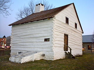
This is an image of a place or building that is listed on the National Register of Historic Places in the United States of America. Its reference number is 79002195. |
Qisqa izoh
| Taʼrif |
English: Log house next to Brandywine Creek in Downingtown, Pennsylvania, on UR Route 30 - the Lincoln Highway Built about 1701. On NRHP |
| Sanasi | |
| Manba | Oʻzimning ishim |
| Muallif | Smallbones |
| Object location | | View this and other nearby images on: OpenStreetMap |
|---|
Litsenziyalash
| I, the copyright holder of this work, release this work into the public domain. This applies worldwide. In some countries this may not be legally possible; if so: I grant anyone the right to use this work for any purpose, without any conditions, unless such conditions are required by law. |
Fayl tarixi
Faylning biror paytdagi holatini koʻrish uchun tegishli sana/vaqtga bosingiz.
| Sana/Vaqt | Miniatura | Oʻlchamlari | Foydalanuvchi | Izoh | |
|---|---|---|---|---|---|
| joriy | 00:07, 13-Yanvar 2010 | | 4 000 × 3 000 (4,35 MB) | Smallbones | {{Information |Description={{en|1=Log house next to Brandywine Creek in Downingtown, Pennsylvania, on UR Route 30 - the Lincoln Highway Built about 1701. On NRHP}} |Source=Own work |Author=Smallbones |Date=2010-01-12 |Permission= |ot |
Fayllarga ishoratlar
Bu faylga quyidagi sahifa bogʻlangan:
Faylning global foydalanilishi
Ushbu fayl quyidagi vikilarda ishlatilyapti:
- ar.wikipedia.org loyihasida foydalanilishi
- ceb.wikipedia.org loyihasida foydalanilishi
- ce.wikipedia.org loyihasida foydalanilishi
- cy.wikipedia.org loyihasida foydalanilishi
- en.wikipedia.org loyihasida foydalanilishi
- en.wikivoyage.org loyihasida foydalanilishi
- eu.wikipedia.org loyihasida foydalanilishi
- ht.wikipedia.org loyihasida foydalanilishi
- hu.wikipedia.org loyihasida foydalanilishi
- it.wikipedia.org loyihasida foydalanilishi
- lld.wikipedia.org loyihasida foydalanilishi
- pt.wikipedia.org loyihasida foydalanilishi
- sr.wikipedia.org loyihasida foydalanilishi
- tl.wikipedia.org loyihasida foydalanilishi
- tt.wikipedia.org loyihasida foydalanilishi
- vi.wikipedia.org loyihasida foydalanilishi
- www.wikidata.org loyihasida foydalanilishi
- zh-min-nan.wikipedia.org loyihasida foydalanilishi