Fayl:Europe laea location map.svg

Size of this PNG preview of this SVG file: 701 × 599 piksel. Boshqa oʻlchamlari: 281 × 240 piksel | 561 × 480 piksel | 898 × 768 piksel | 1 198 × 1 024 piksel | 2 395 × 2 048 piksel | 1 401 × 1 198 piksel.
Asl fayl (SVG fayl, asl oʻlchamlari 1 401 × 1 198 piksel, fayl hajmi: 2,21 MB)
Qisqa izoh
| Taʼrif |
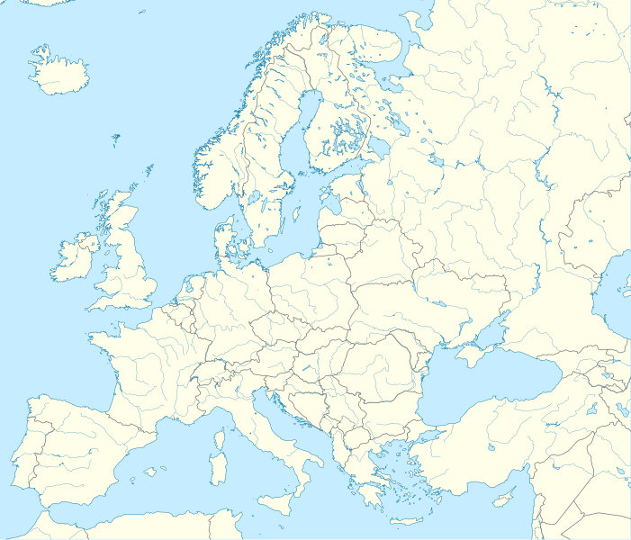
Deutsch: Positionskarte Europa; Politisch mit Staatsgrenzen, Inlandgewässer; Flächentreue Azimutalprojektion
English: Location map Europe; Political with state boundaries, inland water; Lambert azimuthal equal-area projection
Français : Carte de localisation Europe; Politique avec frontières d'Etats, mers intérieures; projection de Lambert azimuthale
Русский: Политическая карта Европы с границами государств и внутренними водами по состоянию на 2010 год (равновеликая азимутальная проекция Ламберта)
|
||
| Sanasi | |||
| Manba |
Oʻzimning ishim
|
||
| Muallif | Alexrk2 | ||
| Other versions |
Derivative works of this file:
[]
|
||
| SVG genesis |
|


.svg)


Litsenziyalash
I, the copyright holder of this work, hereby publish it under the following license:
Bu fayl Creative Commons asosida litsenziyalangan Attribution- Share Alike 3.0 Unported litsenziyasi.
- Siz erkinsiz:
- ulashishga – ishlanmani nusxalash, tarqatish va uzatish
- remiks qilishga – ishni moslashtirishga
- Quyidagi shartlar asosida:
- atribut – Siz tegishli litsenziyaga havolani taqdim etishingiz va oʻzgartirishlar kiritilganligini koʻrsatishingiz kerak. Siz buni har qanday oqilona yoʻl bilan qilishingiz mumkin, lekin litsenziar Sizni yoki Sizning foydalanishingizni ma'qullashini taklif qiladigan tarzda emas.
- bir xil ulashish – Agar Siz materialni remiks qilsangiz, oʻzgartirsangiz yoki unga asoslansangiz, oʻz hissalaringizni asl nusxadagi kabi bir xil yoki mos litsenziya ostida tarqatishingiz kerak.
Fayl tarixi
Faylning biror paytdagi holatini koʻrish uchun tegishli sana/vaqtga bosingiz.
| Sana/Vaqt | Miniatura | Oʻlchamlari | Foydalanuvchi | Izoh | |
|---|---|---|---|---|---|
| joriy | 22:57, 20-Avgust 2012 | | 1 401 × 1 198 (2,21 MB) | McZusatz | Reverted to version as of 19:40, 10 March 2010 (...thumb fixed?) |
| 22:56, 20-Avgust 2012 |  | 1 401 × 1 198 (1,45 MB) | McZusatz | Reverted to version as of 18:44, 10 March 2010 (fixing thumb...) | |
| 19:40, 10-Mart 2010 |  | 1 401 × 1 198 (2,21 MB) | Alexrk2 | +San Marino, enh. coastline & countries | |
| 18:44, 10-Mart 2010 |  | 1 401 × 1 198 (1,45 MB) | Alexrk2 | == Summary == {{Information |Description= {{de|Positionskarte Europa; Politisch mit Staatsgrenzen, Inlandgewässer; Flächentreue Azimutalprojektion}} {{en|Location map Europe; Political with state boundaries, inland water; L |
Fayllarga ishoratlar
Bu faylga bogʻlangan sahifalar yoʻq.
Faylning global foydalanilishi
Ushbu fayl quyidagi vikilarda ishlatilyapti:
- als.wikipedia.org loyihasida foydalanilishi
- an.wikipedia.org loyihasida foydalanilishi
- av.wikipedia.org loyihasida foydalanilishi
- az.wikipedia.org loyihasida foydalanilishi
- Dunay
- Reyn
- UEFA Çempionlar Liqası 1994/1995
- UEFA Çempionlar Liqası 2007/2008
- Şablon:Yer xəritəsi Avropa
- Aqriate
- Akkona (səhra)
- Bardenas-Reales
- Pişinas
- Tabernas (səhra)
- Aleşkov qumları
- Mançester Arenada terror (2017)
- Avropa Gənclər Olimpiya Festivalı
- UEFA Çempionlar Liqası 2017/2018
- Yan çayı
- UEFA Çempionlar Liqası 2018/2019
- Moneqros səhrası
- UEFA Çempionlar Liqası 2019/2020
- UEFA Çempionlar Liqası 2020/2021
- UEFA Çempionlar Liqası 2021/2022
- ba.wikipedia.org loyihasida foydalanilishi
Ushbu faylni koʻproq global foydalanishdan koʻring.