Fayl:Genova mappa metropolitana.svg

Size of this PNG preview of this SVG file: 800 × 584 piksel. Boshqa oʻlchamlari: 320 × 234 piksel | 640 × 467 piksel | 1 024 × 747 piksel | 1 280 × 934 piksel | 2 560 × 1 868 piksel | 1 225 × 894 piksel.
Asl fayl (SVG fayl, asl oʻlchamlari 1 225 × 894 piksel, fayl hajmi: 4,63 MB)
| Description |
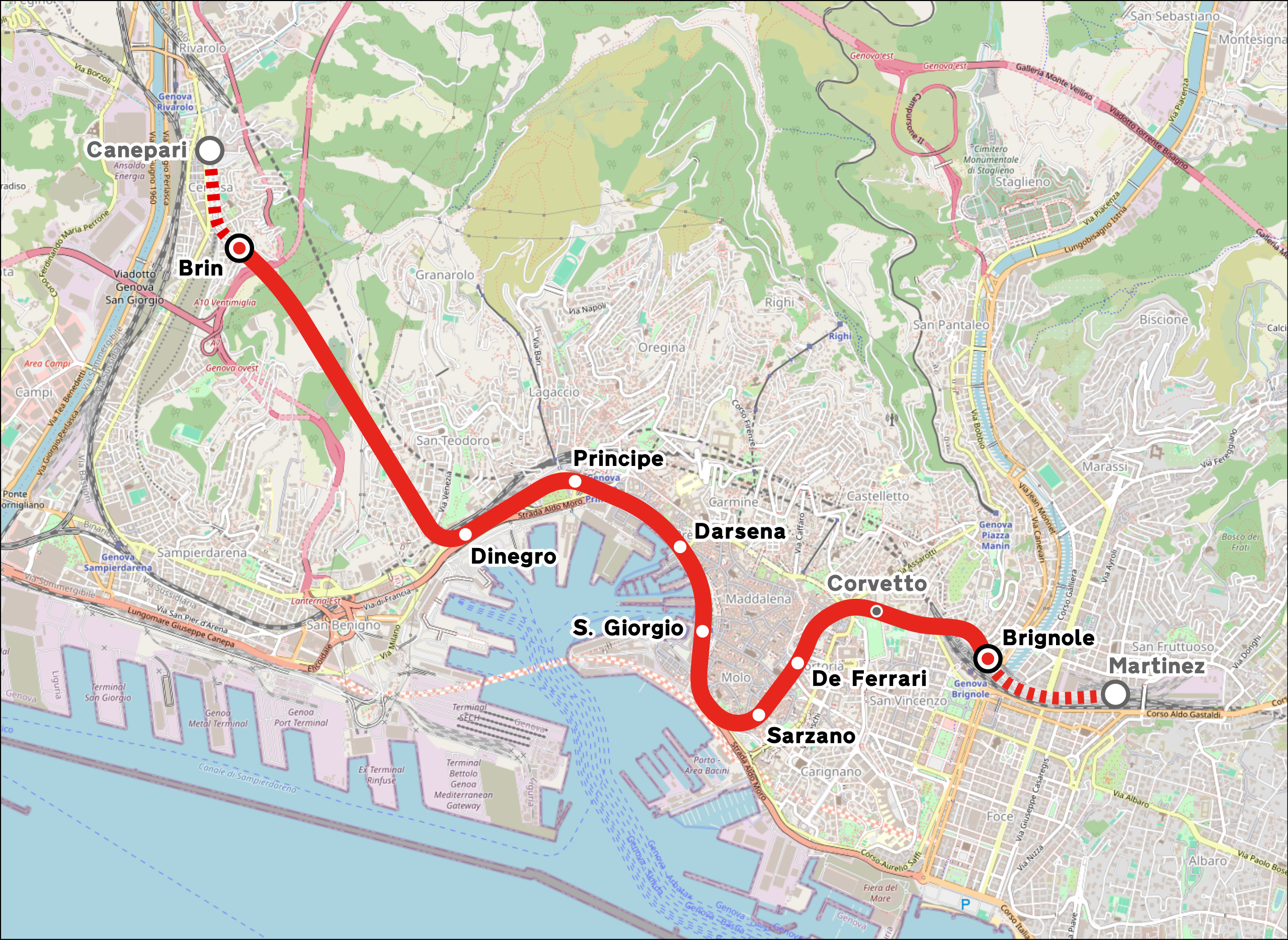
Italiano: Mappa della metropolitana di Genova.
English: Map of Genoa Metro.
Deutsch: Karte der U-Bahn Genua. |
|||
| Sanasi | (see file history) | |||
| Manba | openstreetmap.org | |||
| Yaratuvchi |
OpenStreetMap contributors |
|||
| Ruxsat (Bu faylning takror foydalanilishi) |
OpenStreetMap data is available under the Open Database License (details). Map tiles are licensed under the Creative Commons Attribution-ShareAlike 2.0 license (CC-BY-SA 2.0).
This file is licensed under the Creative Commons Attribution-Share Alike 2.0 Generic license.
|
|||
| Georeferencing | If inappropriate please set warp_status = skip to hide. | |||
| Other versions |
|


Fayl tarixi
Faylning biror paytdagi holatini koʻrish uchun tegishli sana/vaqtga bosingiz.
| Sana/Vaqt | Miniatura | Oʻlchamlari | Foydalanuvchi | Izoh | |
|---|---|---|---|---|---|
| joriy | 03:56, 24-Mart 2024 | | 1 225 × 894 (4,63 MB) | Arbalete | Aggiorno (prolungamento Brignole-Martinez in costruzione) |
| 19:18, 13-Sentyabr 2022 |  | 1 078 × 856 (4,89 MB) | Arbalete | Miglioro grafica (le stazioni in progetto sono variabili...) | |
| 17:15, 20-Yanvar 2022 |  | 632 × 495 (3,96 MB) | Emanuele Lorenzo Corti | Aggiunto servizio ferroviario urbano; stazioni Corvetto e Martinez indicate come progettate, e Canepari indicata come in costruzione. | |
| 10:12, 30-Avgust 2021 |  | 632 × 495 (3,96 MB) | Emanuele Lorenzo Corti | Aggiunte tratte in costruzione Brin - Canepari e Brignole - Martinez | |
| 12:44, 10-Iyun 2014 |  | 632 × 495 (3,95 MB) | Arbalete | Nuovo font | |
| 10:18, 6-Fevral 2014 |  | 632 × 495 (3,93 MB) | Arbalete | Nuova grafica, più chiara. | |
| 14:22, 11-Dekabr 2013 |  | 632 × 495 (3,93 MB) | Arbalete | {{Information |Description ={{en|1=h}} |Source ={{own}} |Author =Friedrichstrasse |Date = |Permission = |other_versions = }} |
Fayllarga ishoratlar
Bu faylga quyidagi sahifa bogʻlangan:
Faylning global foydalanilishi
Ushbu fayl quyidagi vikilarda ishlatilyapti:
- ast.wikipedia.org loyihasida foydalanilishi
- azb.wikipedia.org loyihasida foydalanilishi
- be-tarask.wikipedia.org loyihasida foydalanilishi
- be.wikipedia.org loyihasida foydalanilishi
- bn.wikipedia.org loyihasida foydalanilishi
- ca.wikipedia.org loyihasida foydalanilishi
- cs.wikipedia.org loyihasida foydalanilishi
- de.wikipedia.org loyihasida foydalanilishi
- en.wikipedia.org loyihasida foydalanilishi
- eo.wikipedia.org loyihasida foydalanilishi
- es.wikipedia.org loyihasida foydalanilishi
- eu.wikipedia.org loyihasida foydalanilishi
- fa.wikipedia.org loyihasida foydalanilishi
- fr.wikipedia.org loyihasida foydalanilishi
- hu.wikipedia.org loyihasida foydalanilishi
- id.wikipedia.org loyihasida foydalanilishi
- ja.wikipedia.org loyihasida foydalanilishi
- ka.wikipedia.org loyihasida foydalanilishi
- ko.wikipedia.org loyihasida foydalanilishi
- lmo.wikipedia.org loyihasida foydalanilishi
- lt.wikipedia.org loyihasida foydalanilishi
- nl.wikipedia.org loyihasida foydalanilishi
- pl.wikipedia.org loyihasida foydalanilishi
- pt.wikipedia.org loyihasida foydalanilishi
- ru.wikipedia.org loyihasida foydalanilishi
- th.wikipedia.org loyihasida foydalanilishi
- tr.wikipedia.org loyihasida foydalanilishi
- uk.wikipedia.org loyihasida foydalanilishi
- www.wikidata.org loyihasida foydalanilishi
- zh.wikipedia.org loyihasida foydalanilishi