Fayl:Golan location map 2.PNG

Bu prevyuning hajmi: 759 × 599 piksel. Boshqa oʻlchamlari: 304 × 240 piksel | 608 × 480 piksel | 936 × 739 piksel.
Asl fayl (936 × 739 piksel, fayl hajmi: 140 KB, MIME tipi: image/png)
Qisqa izoh
| Taʼrif |
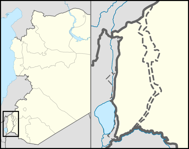
English: Location map of the Golan Heights. |
| Sanasi | |
| Manba | |
| Muallif | |
| Ruxsat (Bu faylning takror foydalanilishi) |
Creative Commons Attribution-Share Alike 3.0 Unported |
| Other versions | File:Golan location map 3.PNG |
Litsenziyalash
This file is licensed under the Creative Commons Attribution 3.0 Unported license.
- Siz erkinsiz:
- ulashishga – ishlanmani nusxalash, tarqatish va uzatish
- remiks qilishga – ishni moslashtirishga
- Quyidagi shartlar asosida:
- atribut – Siz tegishli litsenziyaga havolani taqdim etishingiz va oʻzgartirishlar kiritilganligini koʻrsatishingiz kerak. Siz buni har qanday oqilona yoʻl bilan qilishingiz mumkin, lekin litsenziar Sizni yoki Sizning foydalanishingizni ma'qullashini taklif qiladigan tarzda emas.
Fayl tarixi
Faylning biror paytdagi holatini koʻrish uchun tegishli sana/vaqtga bosingiz.
| Sana/Vaqt | Miniatura | Oʻlchamlari | Foydalanuvchi | Izoh | |
|---|---|---|---|---|---|
| joriy | 23:07, 30-Oktyabr 2012 | | 936 × 739 (140 KB) | LtPowers | Reverted to version as of 21:06, 10 November 2011 |
| 19:19, 30-Oktyabr 2012 |  | 925 × 739 (146 KB) | HonorTheKing | Reverted to version as of 19:37, 10 November 2011 | |
| 21:06, 10-Noyabr 2011 |  | 936 × 739 (140 KB) | LtPowers | Reverted to version as of 18:51, 10 November 2011 | |
| 19:37, 10-Noyabr 2011 |  | 925 × 739 (146 KB) | Jiujitsuguy | Please see talk. Attempt to improve to NPOV showing territory belonging to neither side | |
| 18:51, 10-Noyabr 2011 |  | 936 × 739 (140 KB) | Nableezy | restore | |
| 18:07, 10-Noyabr 2011 |  | 925 × 739 (146 KB) | Chesdovi | "a disputed territory may not be presented in a way that supports one of the sides to the conflict" | |
| 17:00, 10-Noyabr 2011 |  | 936 × 739 (140 KB) | Nableezy | restore | |
| 10:36, 10-Noyabr 2011 |  | 925 × 739 (146 KB) | Biosketch | The image is displayed throughout Wikipedia and should be used to force a POV.. | |
| 04:17, 10-Noyabr 2011 |  | 936 × 739 (140 KB) | Supreme Deliciousness | Restore neutral map. | |
| 03:33, 10-Noyabr 2011 |  | 925 × 739 (146 KB) | Jiujitsuguy | Consistent with NPOV showing Heights controlled by neither side |
Fayllarga ishoratlar
Bu faylga quyidagi 2 sahifalar bogʻlangan:
Faylning global foydalanilishi
Ushbu fayl quyidagi vikilarda ishlatilyapti:
- ar.wikipedia.org loyihasida foydalanilishi
- arz.wikipedia.org loyihasida foydalanilishi
- ba.wikipedia.org loyihasida foydalanilishi
- ca.wikipedia.org loyihasida foydalanilishi
- ceb.wikipedia.org loyihasida foydalanilishi
- ckb.wikipedia.org loyihasida foydalanilishi
- da.wikipedia.org loyihasida foydalanilishi
- de.wikipedia.org loyihasida foydalanilishi
- en.wikipedia.org loyihasida foydalanilishi
- Mount Hermon
- Quneitra
- Bethsaida
- Gamla
- Banias
- Nimrod Castle
- Afik
- Odem
- Buq'ata
- El Rom
- Avnei Eitan
- Rujm el-Hiri
- Ghajar
- Nimrod, Golan Heights
- Neve Ativ
- Keshet, Golan Heights
- Talk:Gamla
- Geshur, Golan Heights
- Mas'ade
- Ramot, Golan Heights
- Yonatan, Golan Heights
- Kfar Haruv
- Mevo Hama
- Beer Ajam
- Alonei HaBashan
- Ani'am
- Bnei Yehuda, Golan Heights
- Givat Yoav
- Haspin
- Ortal, Golan Heights
- Metzar
- Merom Golan
- Natur (Israeli settlement)
- Ein Zivan
- Kanaf
- Ma'ale Gamla
- Neot Golan
- Nov, Golan Heights
Ushbu faylni koʻproq global foydalanishdan koʻring.