Fayl:Landappbw 933759 1817 Ehem. Klosterhof der Probstei Nellingen des Klosters St. Blasien Ostfildern-Nellingen.jpg

Bu prevyuning hajmi: 800 × 533 piksel. Boshqa oʻlchamlari: 320 × 213 piksel | 640 × 427 piksel | 1 024 × 683 piksel | 1 280 × 853 piksel | 1 620 × 1 080 piksel.
Asl fayl (1 620 × 1 080 piksel, fayl hajmi: 330 KB, MIME tipi: image/jpeg)
Qisqa izoh
| Taʼrif |
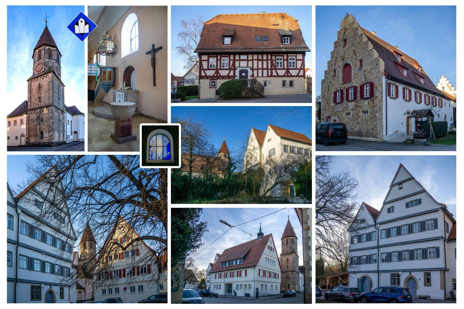
Deutsch: - Das alte Pfarrhaus (Klosterhof 4): Fachwerk-Wohnhaus (16. Jh.), Pfarrhaus bis 1838, heute Bildungs- und Kultureinrichtungen
- Die Ehem. Mesnerei und alten Schule (Klosterhof 6), 1826 durch einen Neubau ersetzt, mehrfach umgebaut, heute Verwaltung - Ev. Pfarrkirche (Klosterhof 8) [offene Kirche]: ehem. Probsteikirche St. Blasius, romanischer Turm (13. Jh.), 1926 Renovierung und Erweiterung - Rathaus (Klosterhof 10): 1954, an Stelle der ehem. Kellerei / württemb. Kanzlei (1649-1838), Rathaus seit 1844, heute Verwaltung - ehem. Probstei und Stabskellerei (ab 1649), seit 1836 Pfarrhaus (Klosterhof 12), heute Bürgermeisteramt - Fruchtkasten (Klosterhof 3) |
| Sanasi | 22 Fevral 2024, 17:57:18 (original upload date) |
| Manba | overview - direct - dataset |
| Muallif | Willi Bautz |
| Ruxsat (Bu faylning takror foydalanilishi) |
Creative Commons Zero (CC0) |
| ID | 933759 |
| Category | 1829 |
| Object location | | View this and other nearby images on: OpenStreetMap |
|---|
This media file was collected by Landauf, LandApp under the ID 933759. This tag does not indicate the copyright status of the attached work. A normal copyright tag is still required. See Commons:Licensing. |
Litsenziyalash
| This file is made available under the Creative Commons CC0 1.0 Universal Public Domain Dedication. | |
| The person who associated a work with this deed has dedicated the work to the public domain by waiving all of their rights to the work worldwide under copyright law, including all related and neighboring rights, to the extent allowed by law. You can copy, modify, distribute and perform the work, even for commercial purposes, all without asking permission.
|
Fayl tarixi
Faylning biror paytdagi holatini koʻrish uchun tegishli sana/vaqtga bosingiz.
| Sana/Vaqt | Miniatura | Oʻlchamlari | Foydalanuvchi | Izoh | |
|---|---|---|---|---|---|
| joriy | 22:52, 23-Fevral 2024 | | 1 620 × 1 080 (330 KB) | LaserlichtBot | =={{int:filedesc}}== {{Information |description={{de|1=- Das alte Pfarrhaus (Klosterhof 4): Fachwerk-Wohnhaus (16. Jh.), Pfarrhaus bis 1838, heute Bildungs- und Kultureinrichtungen - Die Ehem. Mesnerei und alten Schule (Klosterhof 6), 1826 durch einen Neubau ersetzt, mehrfach umgebaut, heute Verwaltung - Ev. Pfarrkirche (Klosterhof 8) [offene Kirche]: ehem. Probsteikirche St. Blasius, romanischer Turm (13. Jh.), 1926 Renovierung und Erweiterung - Rathaus (Klosterhof 10): 1954, an Stelle d... |
Fayllarga ishoratlar
Bu faylga quyidagi sahifa bogʻlangan:
Faylning global foydalanilishi
Ushbu fayl quyidagi vikilarda ishlatilyapti:
- ar.wikipedia.org loyihasida foydalanilishi
- ce.wikipedia.org loyihasida foydalanilishi
- de.wikivoyage.org loyihasida foydalanilishi
- fr.wikipedia.org loyihasida foydalanilishi
- fr.wikivoyage.org loyihasida foydalanilishi
- hu.wikipedia.org loyihasida foydalanilishi
- ku.wikipedia.org loyihasida foydalanilishi
- lld.wikipedia.org loyihasida foydalanilishi
- lmo.wikipedia.org loyihasida foydalanilishi
- mdf.wikipedia.org loyihasida foydalanilishi
- pl.wikipedia.org loyihasida foydalanilishi
- ro.wikipedia.org loyihasida foydalanilishi
- ru.wikipedia.org loyihasida foydalanilishi
- sr.wikipedia.org loyihasida foydalanilishi
- tt.wikipedia.org loyihasida foydalanilishi
- vi.wikipedia.org loyihasida foydalanilishi
- vo.wikipedia.org loyihasida foydalanilishi
- www.wikidata.org loyihasida foydalanilishi