Fayl:Location map of Tazewell County, Illinois.svg

Size of this PNG preview of this SVG file: 600 × 600 piksel. Boshqa oʻlchamlari: 240 × 240 piksel | 480 × 480 piksel | 768 × 768 piksel | 1 024 × 1 024 piksel | 2 048 × 2 048 piksel.
Asl fayl (SVG fayl, asl oʻlchamlari 768 × 768 piksel, fayl hajmi: 233 KB)
Qisqa izoh
| Taʼrif |
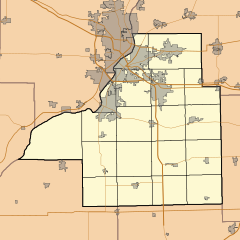
English: This is a map of Tazewell County, Illinois, USA which includes township borders. |
| Sanasi | |
| Manba | My own work, using custom-written MapScript applications with National Atlas and United States Census Bureau data |
| Muallif | Omnedon |
Litsenziyalash
| I, the copyright holder of this work, release this work into the public domain. This applies worldwide. In some countries this may not be legally possible; if so: I grant anyone the right to use this work for any purpose, without any conditions, unless such conditions are required by law. |
Fayl tarixi
Faylning biror paytdagi holatini koʻrish uchun tegishli sana/vaqtga bosingiz.
| Sana/Vaqt | Miniatura | Oʻlchamlari | Foydalanuvchi | Izoh | |
|---|---|---|---|---|---|
| joriy | 22:45, 28-Noyabr 2010 | | 768 × 768 (233 KB) | Omnedon | == {{int:filedesc}} == {{Information |Description={{en|This is a map of Tazewell County, Illinois, USA which includes township borders.}} |Source=My own work, using custom-written MapScript applications with [http://www.na |
Fayllarga ishoratlar
Bu faylga quyidagi 2 sahifalar bogʻlangan:
Faylning global foydalanilishi
Ushbu fayl quyidagi vikilarda ishlatilyapti:
- ar.wikipedia.org loyihasida foydalanilishi
- ceb.wikipedia.org loyihasida foydalanilishi
- en.wikipedia.org loyihasida foydalanilishi
- fa.wikipedia.org loyihasida foydalanilishi
- fr.wikipedia.org loyihasida foydalanilishi
- kn.wikipedia.org loyihasida foydalanilishi
- si.wikipedia.org loyihasida foydalanilishi
- sr.wikipedia.org loyihasida foydalanilishi
- tr.wikipedia.org loyihasida foydalanilishi
- war.wikipedia.org loyihasida foydalanilishi