Fayl:Map of Colchis, Iberia, Albania, and the neighbouring countries ca 1770.jpg

Bu prevyuning hajmi: 800 × 598 piksel. Boshqa oʻlchamlari: 320 × 239 piksel | 640 × 479 piksel | 1 016 × 760 piksel.
Asl fayl (1 016 × 760 piksel, fayl hajmi: 194 KB, MIME tipi: image/jpeg)
Qisqa izoh
| Taʼrif |
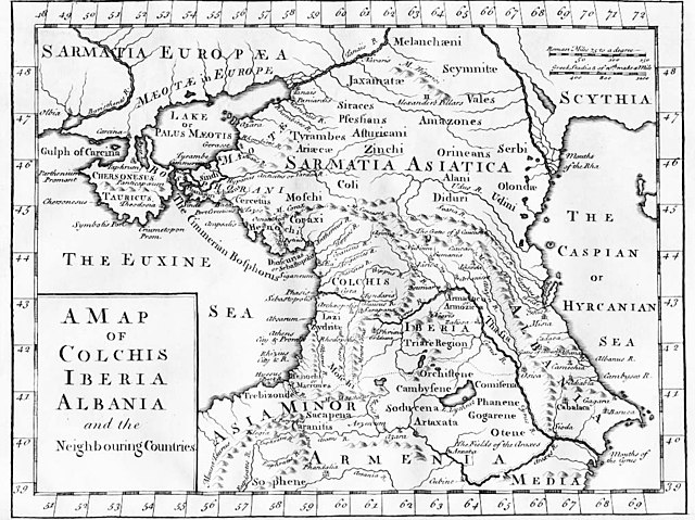
English: "A Map of Colchis, Iberia, Albania, and the neighbouring countries". A map of the Caucasus / Crimea (Chersonesus Tauricus)/ southern Russia region during classical antiquity (the ancient period). Note that the "Albania" referred to was on the Caspian Sea (not the modern Albania in the Balkans). Copper-engraved map, no publisher or date, London, ca 1770 (or 1729?).
Deutsch: Kaukasus mit Siedlungsgebieten von Sarmaten und Amazonen in der Antike, Kupferstich von ca. 1770
Français : La Colchide, l’Ibérie (orientale), l’Albanie (orientale) et les régions voisines
ქართული: ანტიკური ხანის კოლხეთი, ბერძნულ წყაროებზე დაყრდნობით, დაბეჭდილია ლონდონში, 1770.
Nederlands: Kaart van de Kaukasus, ca. 1770
Русский: «Европейская Сарматия». Карта основана на греческих литературных источниках, напечатана в Лондоне в 1770 |
| Sanasi | circa 1770 |
| Manba |
|
| Muallif | last upload en:User:AnonMoos |
Litsenziyalash
|
This is a faithful photographic reproduction of a two-dimensional, public domain work of art. The work of art itself is in the public domain for the following reason:
The official position taken by the Wikimedia Foundation is that "faithful reproductions of two-dimensional public domain works of art are public domain".
This photographic reproduction is therefore also considered to be in the public domain in the United States. In other jurisdictions, re-use of this content may be restricted; see Reuse of PD-Art photographs for details. | ||||
Original upload log
File upload history on en:
- 20:53, 27 October 2005 . . AnonMoos (Talk) . . 1016x760 (198173 bytes) (Version of image losslessly cropped to region of interest with Jpegcrop program. )
- 20:32, 3 July 2005 . . PANONIAN (Talk) . . 1254x760 (224060 bytes) (historic map )
| date/time | username | resolution | size | edit summary | |
|---|---|---|---|---|---|
| 14:53, 29 December 2005 | User:Ustas | <a href="http://upload.wikimedia.org/wikipedia/commons/d/df/1729.jpg"><img alt="Thumbnail for version as of 14:53, 29 December 2005" src="http://upload.wikimedia.org/wikipedia/commons/thumb/d/df/1729.jpg/120px-1729.jpg" width="120" height="90" border="0" /></a> | 1,016×760 | 194 KB | {{Information |Description = Copper-engraved map, no publisher or date, London, ca 1770. |Source = <a href="http://en.wikipedia.org/wiki/Image:1729.jpg" class="extiw" title="en:Image:1729.jpg">en:Image:1729.jpg</a>, [http://www.village-atlas.com/ancient/ancient.html] |Date = |Author = last upload <a href="http://en.wikipedia.org/wiki/User:AnonMoos" class="extiw" title="en:User:AnonMoos">en:User:AnonMoos</a> |Permission = PD |other_ver |
Fayl tarixi
Faylning biror paytdagi holatini koʻrish uchun tegishli sana/vaqtga bosingiz.
| Sana/Vaqt | Miniatura | Oʻlchamlari | Foydalanuvchi | Izoh | |
|---|---|---|---|---|---|
| joriy | 16:02, 22-Oktyabr 2008 | | 1 016 × 760 (194 KB) | BetacommandBot | move approved by: User:Deadstar This image was moved from Image:1729.jpg {{Information |Description = "A Map of Colchis, Iberia, Albania, and the neighbouring countries". A map of the Caucasus / Crimea / southern Russia region during classical |
Fayllarga ishoratlar
Bu faylga quyidagi sahifa bogʻlangan:
Faylning global foydalanilishi
Ushbu fayl quyidagi vikilarda ishlatilyapti:
- als.wikipedia.org loyihasida foydalanilishi
- an.wikipedia.org loyihasida foydalanilishi
- ar.wikipedia.org loyihasida foydalanilishi
- az.wikipedia.org loyihasida foydalanilishi
- ba.wikipedia.org loyihasida foydalanilishi
- bn.wikipedia.org loyihasida foydalanilishi
- ca.wikipedia.org loyihasida foydalanilishi
- co.wikipedia.org loyihasida foydalanilishi
- cy.wikipedia.org loyihasida foydalanilishi
- da.wikipedia.org loyihasida foydalanilishi
- de.wikipedia.org loyihasida foydalanilishi
- el.wikipedia.org loyihasida foydalanilishi
- en.wikipedia.org loyihasida foydalanilishi
- es.wikipedia.org loyihasida foydalanilishi
- eu.wikipedia.org loyihasida foydalanilishi
- fa.wikipedia.org loyihasida foydalanilishi
- fi.wikipedia.org loyihasida foydalanilishi
- fr.wikipedia.org loyihasida foydalanilishi
- fy.wikipedia.org loyihasida foydalanilishi
- gl.wikipedia.org loyihasida foydalanilishi
- he.wikipedia.org loyihasida foydalanilishi
- hr.wikipedia.org loyihasida foydalanilishi
- hu.wikipedia.org loyihasida foydalanilishi
- hyw.wikipedia.org loyihasida foydalanilishi
- it.wikipedia.org loyihasida foydalanilishi
Ushbu faylni koʻproq global foydalanishdan koʻring.