Fayl:Mount Chokai Relief Map, SRTM-1.jpg

Bu prevyuning hajmi: 450 × 600 piksel. Boshqa oʻlchamlari: 180 × 240 piksel | 360 × 480 piksel | 900 × 1 200 piksel.
Asl fayl (900 × 1 200 piksel, fayl hajmi: 745 KB, MIME tipi: image/jpeg)
Qisqa izoh
| Taʼrif |
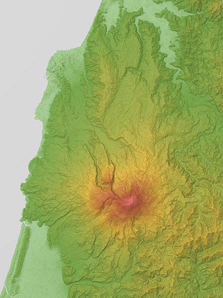
English: Mount Chokai is a volcano in the border between Yamagata and Akita Prefectures, Honshu, Japan.
|
| Sanasi | |
| Manba |
Topographic data: NASA's SRTM-1 30m Mesh (ver.3 2014) |
| Muallif | Batholith |
| Object location | | View this and other nearby images on: OpenStreetMap |
|---|
Litsenziyalash
| I, the copyright holder of this work, release this work into the public domain. This applies worldwide. In some countries this may not be legally possible; if so: I grant anyone the right to use this work for any purpose, without any conditions, unless such conditions are required by law. |
This image uses high-resolution digital topography data from NASA's Shuttle Radar Topography Mission (SRTM) at JPL-Caltech [1]. It is in the public domain in the United States.
|
 | |
Fayl tarixi
Faylning biror paytdagi holatini koʻrish uchun tegishli sana/vaqtga bosingiz.
| Sana/Vaqt | Miniatura | Oʻlchamlari | Foydalanuvchi | Izoh | |
|---|---|---|---|---|---|
| joriy | 09:59, 1-Mart 2016 | | 900 × 1 200 (745 KB) | Batholith | {{Information |Description= {{en|Relief map of Mount Chōkai, Yamagata Prefecture & Akita Prefecture, Tōhoku region, Honshu, Japan. From... |
Fayllarga ishoratlar
Bu faylga quyidagi sahifa bogʻlangan:
Faylning global foydalanilishi
Ushbu fayl quyidagi vikilarda ishlatilyapti:
- en.wikipedia.org loyihasida foydalanilishi
- ja.wikipedia.org loyihasida foydalanilishi
- th.wikipedia.org loyihasida foydalanilishi