Fayl:Naajaat panorama 2007-08-09 2 cropped USM downsampled edit.jpg

Bu prevyuning hajmi: 800 × 172 piksel. Boshqa oʻlchamlari: 320 × 69 piksel | 640 × 138 piksel | 1 024 × 220 piksel | 1 280 × 275 piksel | 5 224 × 1 124 piksel.
Asl fayl (5 224 × 1 124 piksel, fayl hajmi: 6,43 MB, MIME tipi: image/jpeg)
Qisqa izoh
| Taʼrif |
Dansk: Panorama ud over den lille nordvestgrønlandske bydg Naajaat. I baggrunden til venstre ses indlandsisen. Panoramaet er skabt i PTGui med Smartblend ud fra håndholdte billeder taget med et Canon IXUS 800 IS kompaktkamera.
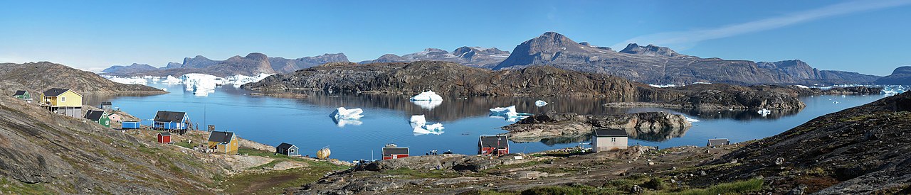
English: Panorama of the small settlement Naajaat in North-West Greenland. The Greenland ice sheet is seen to the upper left. The panoramic is based on hand-held photos taken with a Canon IXUS 800 IS compact camera. The stiching was done in PTGui with Smartblend.
Español: Vista panorámica del pueblo de Naajaat en el noroeste de Groenlandia (9 de agosto de 2007). Se puede ver la capa de hielo en la parte superior izquierda.
Français : Le village de Naajaat dans le Nord-Ouest du Groenland. On peut voir la calotte glaciaire en haut à gauche. Image panoramique obtenue en utilisant PTGui à partir de photos réalisées avec un appareil photo digital compact Canon IXUS 800 IS.
Українська: Невеличке поселення Нааяат у північно-західній Ґренландії, 9 серпня, 2007. У лівому верхньому куті видно Ґренландський льодовиковий щит
Português: Vista panorâmica do assentamento de Naajaat no noroeste da Groenlândia (9 de agosto de 2007). Pode-se ver o manto de gelo no canto superior esquerdo.
Bosanski: Malehno naselje Naajaat na sjeverozapadu Grenlanda 9. augusta 2007. Na gornjem lijevo uglu vidljiv je i dio grenlandskog ledenog štita.
Čeština: Malá osada Naajaat v severozápadním Grónsku, 9. srpna, 2007. Na snímku nahoře vlevo je patrný Grónský ledovec.
Magyar: A nyugat-grönlandi Naajaat település látképe. Bal felső sarokban a grönlandi jégtakaró látható
|
| Sanasi |
|
| Manba | |
| Muallif |
|
| Camera location | | View this and other nearby images on: OpenStreetMap |
|---|
| This is a retouched picture, which means that it has been digitally altered from its original version. Modifications: Exposure clipping removed. The original can be viewed here: Naajaat panorama 2007-08-09 2 cropped USM downsampled.jpg:
|
This image was selected as picture of the day on Wikimedia Commons for 8 August 2015. It was captioned as follows: English: The small settlement Naajaat in Northwest Greenland, August 9, 2007. The Greenland ice sheet is seen to the upper left. Other languages:
Bosanski: Malehno naselje Naajaat na sjeverozapadu Grenlanda 9. augusta 2007. Na gornjem lijevo uglu vidljiv je i dio grenlandskog ledenog štita. Čeština: Malá osada Naajaat v severozápadním Grónsku, 9. srpna, 2007. Na snímku nahoře vlevo je patrný Grónský ledovec. English: The small settlement Naajaat in Northwest Greenland, August 9, 2007. The Greenland ice sheet is seen to the upper left. Español: Vista panorámica del pueblo de Naajaat en el noroeste de Groenlandia (9 de agosto de 2007). Se puede ver la capa de hielo en la parte superior izquierda. Magyar: A nyugat-grönlandi Naajaat település látképe. Bal felső sarokban a grönlandi jégtakaró látható Nederlands: De kleine nederzetting Naajaat in noordwest Groenland met linksachter in beeld de Groenlandse ijskap. Português: Vista panorâmica do assentamento de Naajaat no noroeste da Groenlândia (9 de agosto de 2007). Pode-se ver o manto de gelo no canto superior esquerdo. Українська: Невеличке поселення Нааяат у північно-західній Ґренландії, 9 серпня, 2007. У лівому верхньому куті видно Ґренландський льодовиковий щит |
|
Litsenziyalash
I, the copyright holder of this work, hereby publish it under the following licenses:
This file is licensed under the Creative Commons Attribution-Share Alike 3.0 Unported, 2.5 Generic, 2.0 Generic and 1.0 Generic license.
- Siz erkinsiz:
- ulashishga – ishlanmani nusxalash, tarqatish va uzatish
- remiks qilishga – ishni moslashtirishga
- Quyidagi shartlar asosida:
- atribut – Siz tegishli litsenziyaga havolani taqdim etishingiz va oʻzgartirishlar kiritilganligini koʻrsatishingiz kerak. Siz buni har qanday oqilona yoʻl bilan qilishingiz mumkin, lekin litsenziar Sizni yoki Sizning foydalanishingizni ma'qullashini taklif qiladigan tarzda emas.
- bir xil ulashish – Agar Siz materialni remiks qilsangiz, oʻzgartirsangiz yoki unga asoslansangiz, oʻz hissalaringizni asl nusxadagi kabi bir xil yoki mos litsenziya ostida tarqatishingiz kerak.

|
Ushbu hujjatdan nusxa ko‘chirish, tarqatish va/yoki o‘zgartirish uchun GNU Erkin guvohnoma litsenziyasi (GNU Free Documentation License), 1.2 va har qanday keyingi versiyalar shartlariga muvofiq ruxsat berilgan yoki Ochiq kodli dasturlar jamiyati (Free Software Foundation) tomonidan chop etilgan; oʻzgarmas boʻlimlarsiz, oldingi muqova matnlari va orqa muqova matnlarisiz. Litsenziya nusxasi GNU Erkin guvohnoma litsenziyasi (GNU Free Documentation License) boʻlimiga kiritilgan. |
Siz oʻzingiz xohlagan litsenziyani tanlashingiz mumkin.
Original upload log
This image is a derivative work of the following images:
- File:Naajaat_panorama_2007-08-09_2_cropped_USM_downsampled.jpg licensed with Cc-by-sa-3.0,2.5,2.0,1.0, GFDL
- 2010-02-27T01:17:30Z Noodle snacks 5224x1124 (6667230 Bytes) selective sharpen a spot.
- 2010-02-27T01:15:41Z Noodle snacks 5224x1124 (6667230 Bytes) restitch
- 2007-12-21T22:05:48Z Slaunger 5900x1200 (2083239 Bytes) {{Information |Description= {{da|Panorama ud over den lille nordvestgrønlandske bydg [[:da:Naajaat|Naajaat]]. I baggrunden til venstre ses indlandsisen.}} {{en|Panorama of the small settlement [[w:Naajaat|Naajaat]] in North-
Uploaded with derivativeFX
| Annotations | This image is annotated: View the annotations at Commons |
Fayl tarixi
Faylning biror paytdagi holatini koʻrish uchun tegishli sana/vaqtga bosingiz.
| Sana/Vaqt | Miniatura | Oʻlchamlari | Foydalanuvchi | Izoh | |
|---|---|---|---|---|---|
| joriy | 11:37, 28-Fevral 2010 | 5 224 × 1 124 (6,43 MB) | Herbythyme | {{Information |Description={{da|Panorama ud over den lille nordvestgrønlandske bydg Naajaat. I baggrunden til venstre ses indlandsisen. Panoramaet er skabt i Hugin ud fra håndholdte billeder taget med et [[w:Canon |
Fayllarga ishoratlar
Bu faylga quyidagi sahifa bogʻlangan:
Faylning global foydalanilishi
Ushbu fayl quyidagi vikilarda ishlatilyapti:
- be-tarask.wikipedia.org loyihasida foydalanilishi
- bg.wikipedia.org loyihasida foydalanilishi
- bn.wikipedia.org loyihasida foydalanilishi
- ca.wikipedia.org loyihasida foydalanilishi
- ceb.wikipedia.org loyihasida foydalanilishi
- crh.wikipedia.org loyihasida foydalanilishi
- cs.wikipedia.org loyihasida foydalanilishi
- cv.wikipedia.org loyihasida foydalanilishi
- da.wikipedia.org loyihasida foydalanilishi
- de.wikipedia.org loyihasida foydalanilishi
- en.wikipedia.org loyihasida foydalanilishi
- Naajaat
- Wikipedia:Featured pictures/Places/Panorama
- User:Slaunger
- Talk:Naajaat
- User talk:Slaunger
- Wikipedia:Featured pictures thumbs/22
- Wikipedia:Featured picture candidates/Naajaat
- Wikipedia:Featured picture candidates/March-2010
- Wikipedia:Wikipedia Signpost/2010-03-08/Features and admins
- Upernavik Archipelago
- User talk:JJ Harrison/Archive3
- Wikipedia:Picture of the day/October 2011
- Template:POTD/2011-10-17
- Wikipedia:Main Page history/2011 October 17
- Portal:Islands/Selected picture
- Portal:Islands/Selected picture/8
- Wikipedia:Wikipedia Signpost/Single/2010-03-08
- en.wikiversity.org loyihasida foydalanilishi
- es.wikipedia.org loyihasida foydalanilishi
- fa.wikipedia.org loyihasida foydalanilishi
- fr.wikipedia.org loyihasida foydalanilishi
- hu.wikipedia.org loyihasida foydalanilishi
- ilo.wikipedia.org loyihasida foydalanilishi
- Plantilia:Napili a ladawan ita nga aldaw/Agosto 5
- Plantilia:Napili a ladawan ita nga aldaw/Oktubre 5
- Plantilia:Napili a ladawan ita nga aldaw/Disiembre 5
- Plantilia:Napili a ladawan ita nga aldaw/Pebrero 5
- Plantilia:Napili a ladawan ita nga aldaw/Abril 5
- Plantilia:Napili a ladawan ita nga aldaw/Hunio 5
- it.wikipedia.org loyihasida foydalanilishi
- iu.wikipedia.org loyihasida foydalanilishi
- ka.wikipedia.org loyihasida foydalanilishi
- kl.wikipedia.org loyihasida foydalanilishi
- ko.wikipedia.org loyihasida foydalanilishi
Ushbu faylni koʻproq global foydalanishdan koʻring.