Fayl:Rakahanga.jpg
Bu prevyuning hajmi: 509 × 600 piksel. Boshqa oʻlchamlari: 204 × 240 piksel | 634 × 747 piksel.
Asl fayl (634 × 747 piksel, fayl hajmi: 131 KB, MIME tipi: image/jpeg)
Qisqa izoh
| Taʼrif |
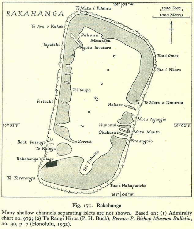
English: Map of Rakahanga Atoll, Northern Cook Islands |
| Sanasi | |
| Manba | http://www.lib.utexas.edu/maps/historical/pacific_islands_1943_1945/rakahanga.jpg |
| Muallif | US Army |
Litsenziyalash
This file is in the public domain because it has been taken from a collection of public domain maps at the University of Texas Library
|
Fayl tarixi
Faylning biror paytdagi holatini koʻrish uchun tegishli sana/vaqtga bosingiz.
| Sana/Vaqt | Miniatura | Oʻlchamlari | Foydalanuvchi | Izoh | |
|---|---|---|---|---|---|
| joriy | 17:19, 10-Avgust 2008 | | 634 × 747 (131 KB) | Ratzer | {{Information |Description={{en|1=Map of Rakahanga Atoll, Northern Cook Islands}} |Source=http://www.lib.utexas.edu/maps/historical/pacific_islands_1943_1945/rakahanga.jpg |Author=US Army |Date=1943 |Permission= |other_versions= }} {{ImageUpload|full}} |
Fayllarga ishoratlar
Bu faylga quyidagi 9 sahifalar bogʻlangan:
Faylning global foydalanilishi
Ushbu fayl quyidagi vikilarda ishlatilyapti:
- bcl.wikipedia.org loyihasida foydalanilishi
- ca.wikipedia.org loyihasida foydalanilishi
- ceb.wikipedia.org loyihasida foydalanilishi
- cs.wikipedia.org loyihasida foydalanilishi
- de.wikipedia.org loyihasida foydalanilishi
- en.wikipedia.org loyihasida foydalanilishi
- es.wikipedia.org loyihasida foydalanilishi
- id.wikipedia.org loyihasida foydalanilishi
- is.wikipedia.org loyihasida foydalanilishi
- it.wikipedia.org loyihasida foydalanilishi
- ka.wikipedia.org loyihasida foydalanilishi
- la.wikipedia.org loyihasida foydalanilishi
- lt.wikipedia.org loyihasida foydalanilishi
- mt.wikipedia.org loyihasida foydalanilishi
- ru.wikipedia.org loyihasida foydalanilishi
- simple.wikipedia.org loyihasida foydalanilishi
- su.wikipedia.org loyihasida foydalanilishi
- sv.wikipedia.org loyihasida foydalanilishi
- tr.wikipedia.org loyihasida foydalanilishi
- www.wikidata.org loyihasida foydalanilishi