Fayl:Tang outline map, 661.svg

Size of this PNG preview of this SVG file: 800 × 470 piksel. Boshqa oʻlchamlari: 320 × 188 piksel | 640 × 376 piksel | 1 024 × 602 piksel | 1 280 × 752 piksel | 2 560 × 1 505 piksel | 1 288 × 757 piksel.
Asl fayl (SVG fayl, asl oʻlchamlari 1 288 × 757 piksel, fayl hajmi: 64 KB)
Qisqa izoh
| Description |
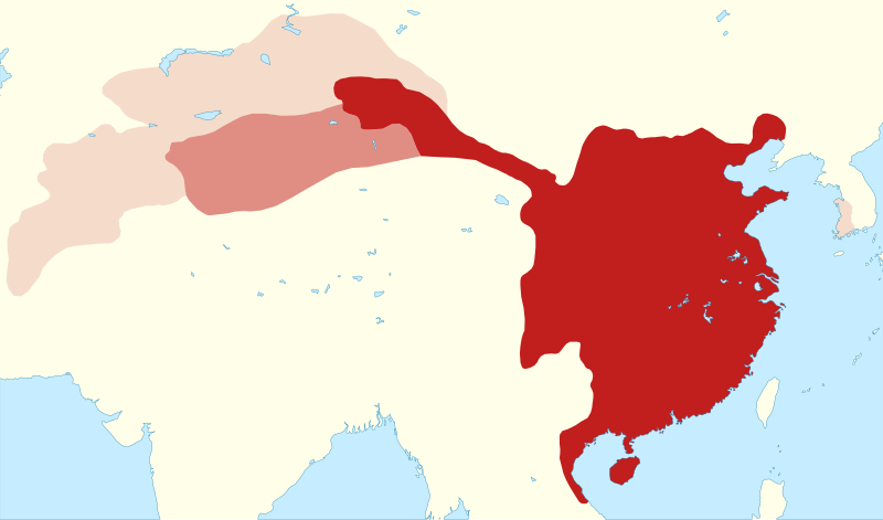
English: Outline map of the Tang empire in 661, when it reached its greatest extent. |
|||||||||
| Map legend |
civil administration
military administration (Anxi protectorate): 649–670 and 675–755
briefly-controlled areas: Kunling, Mengchi, Sogdiana and Tokharistan protectorates (established 657–661, overthrown 665), Ungjin Commandery (660–671) |
|||||||||
| Sanasi | ||||||||||
| Manba |
Oʻzimning ishim
|
|||||||||
| Yaratuvchi | ||||||||||
| Geotemporal data | ||||||||||
| Date depicted | ||||||||||
| Spatial reference system | equirectangular | |||||||||
| Heading |
 |
|||||||||
| Bounding box |
|
|||||||||
| Other versions |
 |
|||||||||
| SVG genesis | ||||||||||
Litsenziyalash
I, the copyright holder of this work, hereby publish it under the following licenses:
This file is licensed under the Creative Commons Attribution-Share Alike 4.0 International license.
- Siz erkinsiz:
- ulashishga – ishlanmani nusxalash, tarqatish va uzatish
- remiks qilishga – ishni moslashtirishga
- Quyidagi shartlar asosida:
- atribut – Siz tegishli litsenziyaga havolani taqdim etishingiz va oʻzgartirishlar kiritilganligini koʻrsatishingiz kerak. Siz buni har qanday oqilona yoʻl bilan qilishingiz mumkin, lekin litsenziar Sizni yoki Sizning foydalanishingizni ma'qullashini taklif qiladigan tarzda emas.
- bir xil ulashish – Agar Siz materialni remiks qilsangiz, oʻzgartirsangiz yoki unga asoslansangiz, oʻz hissalaringizni asl nusxadagi kabi bir xil yoki mos litsenziya ostida tarqatishingiz kerak.

|
Ushbu hujjatdan nusxa ko‘chirish, tarqatish va/yoki o‘zgartirish uchun GNU Erkin guvohnoma litsenziyasi (GNU Free Documentation License), 1.2 va har qanday keyingi versiyalar shartlariga muvofiq ruxsat berilgan yoki Ochiq kodli dasturlar jamiyati (Free Software Foundation) tomonidan chop etilgan; oʻzgarmas boʻlimlarsiz, oldingi muqova matnlari va orqa muqova matnlarisiz. Litsenziya nusxasi GNU Erkin guvohnoma litsenziyasi (GNU Free Documentation License) boʻlimiga kiritilgan. |
Siz oʻzingiz xohlagan litsenziyani tanlashingiz mumkin.
Fayl tarixi
Faylning biror paytdagi holatini koʻrish uchun tegishli sana/vaqtga bosingiz.
| Sana/Vaqt | Miniatura | Oʻlchamlari | Foydalanuvchi | Izoh | |
|---|---|---|---|---|---|
| joriy | 07:48, 27-Mart 2024 | | 1 288 × 757 (64 KB) | Kanguole | fix XML markup errors (bad characters in id's) |
| 22:52, 24-Mart 2024 |  | 1 288 × 757 (64 KB) | Kanguole | minor update to northern boundary | |
| 20:46, 22-Iyun 2023 |  | 1 288 × 757 (63 KB) | Kanguole | add Ungjin Commandery (660–671) | |
| 15:18, 7-May 2023 |  | 1 195 × 757 (56 KB) | Kanguole | {{Map |Description={{en|1=Outline map of the Tang empire in 661, when it reached its greatest extent.}} |Legend= {{legend|#c11e1e|civil administration}} {{legend|#df8d83|military administration (Anxi protectorate): 649–670 and 675–755}} {{legend|#f7dcca|briefly-controlled protectorates (Kunling, Mengchi, Sogdiana, Tokharistan): established 657–661, overthrown 665}} |Date=2023-05-07 |Source={{own}} * Boundaries from ** Twitchett, Denis and Wechsler, Howard J. (1979). "Kao-tsung (reign 649-83)... |
Fayllarga ishoratlar
Bu faylga quyidagi sahifa bogʻlangan:
Faylning global foydalanilishi
Ushbu fayl quyidagi vikilarda ishlatilyapti:
- de.wikipedia.org loyihasida foydalanilishi
- en.wikipedia.org loyihasida foydalanilishi
- fa.wikipedia.org loyihasida foydalanilishi
- ja.wikipedia.org loyihasida foydalanilishi
- ko.wikipedia.org loyihasida foydalanilishi
- sl.wikipedia.org loyihasida foydalanilishi
- tr.wikipedia.org loyihasida foydalanilishi
- uk.wikipedia.org loyihasida foydalanilishi