Fayl:UNRWA Fields of Operations Map 2017.pdf

Asl fayl (1 793 × 2 502 piksel, fayl hajmi: 732 KB, MIME tipi: application/pdf)
Qisqa izoh
| Taʼrif |
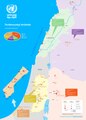
English: A map of the fields of operations of UNRWA, as of 1 January 2017 |
| Sanasi | |
| Manba | United Nations Relief and Works Agency for Palestine Refugees in the Near East: Source |
| Muallif | United Nations Relief and Works Agency for Palestine Refugees in the Near East, United Nations |
| Other versions |
|
Litsenziyalash
| This image is a map derived from a United Nations map.
Unless stated otherwise, UN maps are to be considered in the public domain. This applies worldwide. UN maps are, in principle, open source material and you can use them in your work or for making your own map. UN requests however that you delete the UN name, logo and reference number upon any modification to the map. Content of your map will be your responsibility. You can state in your publication, if you wish, something like: based on UN map … (map name, map number, revision number and date). See: Geospatial Information Section. And: Geospatial, location data for a better world. |
 |
Fayl tarixi
Faylning biror paytdagi holatini koʻrish uchun tegishli sana/vaqtga bosingiz.
| Sana/Vaqt | Miniatura | Oʻlchamlari | Foydalanuvchi | Izoh | |
|---|---|---|---|---|---|
| joriy | 20:45, 16-Dekabr 2018 |  | 1 793 × 2 502 (732 KB) | Jesuiseduardo | User created page with UploadWizard |
Fayllarga ishoratlar
Bu faylga quyidagi sahifa bogʻlangan:
Faylning global foydalanilishi
Ushbu fayl quyidagi vikilarda ishlatilyapti:
- bn.wikipedia.org loyihasida foydalanilishi
- en.wikipedia.org loyihasida foydalanilishi
- eo.wikipedia.org loyihasida foydalanilishi
- es.wikipedia.org loyihasida foydalanilishi
- fa.wikipedia.org loyihasida foydalanilishi
- fi.wikipedia.org loyihasida foydalanilishi
- fr.wikipedia.org loyihasida foydalanilishi
- id.wikipedia.org loyihasida foydalanilishi
- lt.wikipedia.org loyihasida foydalanilishi
- simple.wikipedia.org loyihasida foydalanilishi
- zh.wikipedia.org loyihasida foydalanilishi