Fayl:Map of Constantinople (1422) by Florentine cartographer Cristoforo Buondelmonte.jpg
Bu prevyuning hajmi: 476 × 600 piksel. Boshqa oʻlchamlari: 190 × 240 piksel | 592 × 746 piksel.
Asl fayl (592 × 746 piksel, fayl hajmi: 838 KB, MIME tipi: image/jpeg)
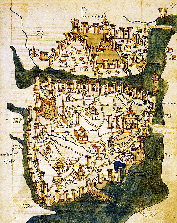
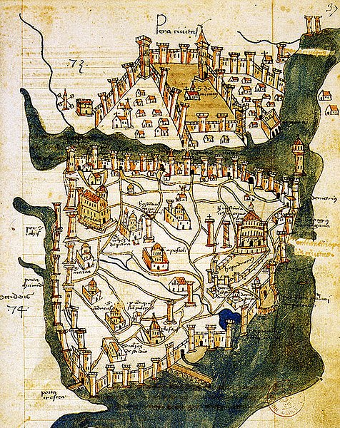
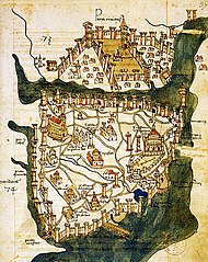
| Taʼrif | Map of Constantinople (a small part of modern Istanbul), called "Historic Peninsula", Tarihi Yarımada en Turkish) designed in 1422 by Florentine cartographer Cristoforo Buondelmonti (Description des îles de l'archipel, Bibliothèque nationale, Paris) is the oldest surviving map of the city, and the only surviving map which predates the Turkish conquest of Constantinople in 1453. | ||||
| Sanasi | |||||
| Manba | Liber insularum Archipelagi (1824), version available at the Bibliothèque nationale de France, Paris | ||||
| Muallif | Cristoforo Buondelmonti | ||||
| Ruxsat (Bu faylning takror foydalanilishi) |
|
||||
| Other versions |
|
||||

_by_Florentine_cartographer_Cristoforo_Buondelmonte.jpg)
Fayl tarixi
Faylning biror paytdagi holatini koʻrish uchun tegishli sana/vaqtga bosingiz.
| Sana/Vaqt | Miniatura | Oʻlchamlari | Foydalanuvchi | Izoh | |
|---|---|---|---|---|---|
| joriy | 10:24, 25-Iyun 2007 | | 592 × 746 (838 KB) | M.K. | {{Information |Description=Map of Constantinople (1422) by Florentine cartographer Cristoforo Buondelmonte (''Description des îles de l'archipel'', Bibliothèque nationale, Paris) is the oldest surviving map of the city, and the only surviving ma |
Fayllarga ishoratlar
Bu faylga quyidagi 2 sahifalar bogʻlangan:
Faylning global foydalanilishi
Ushbu fayl quyidagi vikilarda ishlatilyapti:
- ar.wikipedia.org loyihasida foydalanilishi
- az.wikipedia.org loyihasida foydalanilishi
- ba.wikipedia.org loyihasida foydalanilishi
- bg.wikipedia.org loyihasida foydalanilishi
- ca.wikipedia.org loyihasida foydalanilishi
- ce.wikipedia.org loyihasida foydalanilishi
- cs.wikipedia.org loyihasida foydalanilishi
- de.wikipedia.org loyihasida foydalanilishi
- el.wikipedia.org loyihasida foydalanilishi
- en.wikipedia.org loyihasida foydalanilishi
- Bosporus
- Constantinople
- Constantine XI Palaiologos
- John VII Palaiologos
- Walls of Constantinople
- Beyoğlu
- Maiden's Tower
- Siege of Constantinople (1422)
- Siege of Constantinople (1411)
- Template:Did you know nominations/Kontoskalion
- Piyalepaşa, Beyoğlu
- Wikipedia:Main Page history/2019 February 23
- Siege of Constantinople (1394–1402)
- es.wikipedia.org loyihasida foydalanilishi
- et.wikipedia.org loyihasida foydalanilishi
- eu.wikipedia.org loyihasida foydalanilishi
- fa.wikipedia.org loyihasida foydalanilishi
- frp.wikipedia.org loyihasida foydalanilishi
- fr.wikipedia.org loyihasida foydalanilishi
Ushbu faylni koʻproq global foydalanishdan koʻring.
_by_Florentine_cartographer_Cristoforo_Buondelmonte.jpg)
_by_Florentine_cartographer_Cristoforo_Buondelmonte.jpg)