Fayl:Thermopylae map 480bc.png
Bundan kattaroq tasvir yoʻq.
Thermopylae_map_480bc.png (542 × 417 piksel, fayl hajmi: 24 KB, MIME tipi: image/png)
Qisqa izoh
| Taʼrif |
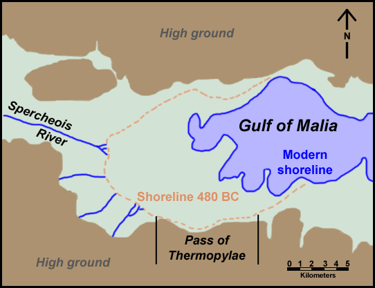
English: Map of Thermopylae area with modern shoreline and reconstructed shoreline of 480 BC. Loosely based on figure 3.19 in Geoarchaeology: The Earth-science Approach to Archaeological Interpretation, p. 96. George Robert Rapp, Christopher L. Hill. Yale University Press, 2006. ISBN 0300109660 |
| Sanasi | |
| Manba | Oʻzimning ishim |
| Muallif | ChrisO |
| Ruxsat (Bu faylning takror foydalanilishi) |
Public domain |
| Other versions | Derivative works of this file: Thermopylae map 480bc-es.svg |
Litsenziyalash
| I, the copyright holder of this work, release this work into the public domain. This applies worldwide. In some countries this may not be legally possible; if so: I grant anyone the right to use this work for any purpose, without any conditions, unless such conditions are required by law. |
Fayl tarixi
Faylning biror paytdagi holatini koʻrish uchun tegishli sana/vaqtga bosingiz.
| Sana/Vaqt | Miniatura | Oʻlchamlari | Foydalanuvchi | Izoh | |
|---|---|---|---|---|---|
| joriy | 23:59, 30-Sentyabr 2008 | | 542 × 417 (24 KB) | ChrisO | {{Information |Description={{en|1=Map of Thermopylae area with modern shoreline and reconstructed shoreline of 480 BC. Loosely based on figure 3.19 in ''Geoarchaeology: The Earth-science Approach to Archaeological Interpretation'', p. 96. George Robert Ra |
Fayllarga ishoratlar
Bu faylga quyidagi sahifa bogʻlangan:
Faylning global foydalanilishi
Ushbu fayl quyidagi vikilarda ishlatilyapti:
- azb.wikipedia.org loyihasida foydalanilishi
- fi.wikipedia.org loyihasida foydalanilishi
- fr.wikipedia.org loyihasida foydalanilishi
- ko.wikipedia.org loyihasida foydalanilishi
- mk.wikipedia.org loyihasida foydalanilishi
- tr.wikipedia.org loyihasida foydalanilishi